Xinjiang Tianshan (1414)
 Xinjiang Tianshan is a diverse landscape of unique geographical and physical feature and is also famous as “Mountains in the Paradise” for its natural and breathtakingly beautiful landscapes. The property was inscribed as UNESCO World Heritage Site in 2013, since then the Outstanding Universal Value of the property has been intact. Xinjiang Tianshanis an important refuge for various endangered and endemic flora and fauna species such as Picea schrenkiana, Sorbus tianschanica, Lutra lutra, Ursus arctos, Panthera uncia (Snow leopard), Ammopiptanthus nanu, Armeniaca vulgaris, Epipactis helleborine, Orchis latifolia, O. cruenta, O. umbrosa. The property is very well protected from the extrinsic threats, but the only concern is sudden increase in tourism. An increase in number of visitors will lead to increase in tourism infrastructure which in turn will cause harm to the OUV and other attributes of the property. The uncertain involvement of local stakeholders and communities also worries the administration. The IUCN world heritage outlook of the property shows that the property falls under the ‘Good with some concern’ category. Since ancient times Mount Tianshan in Xinjiang is a scared place for Chinese people and all the ethnic locals of Xinjiang are referred to as “the children of Tianshan Mountains”.
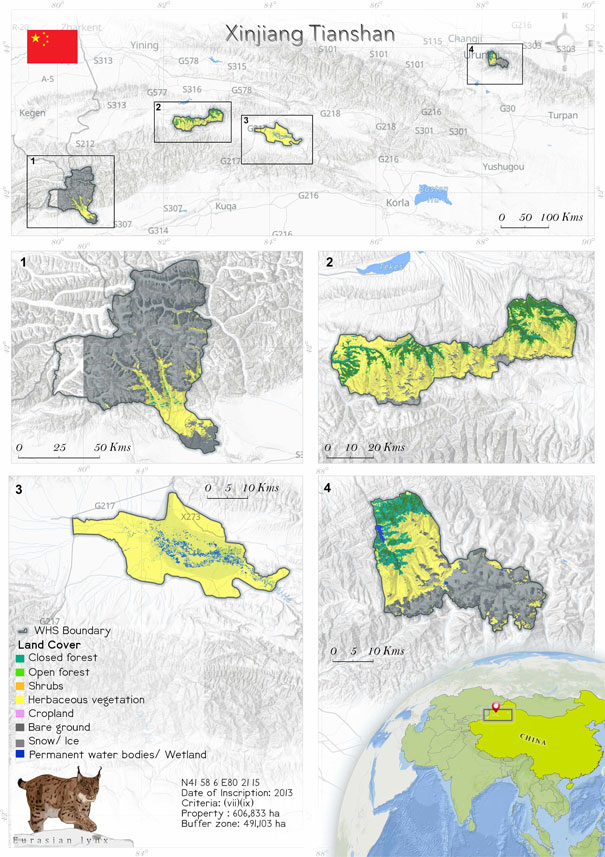
 Xinjiang Tinshan is anoutstanding representative of contrasting visuals;the montane landscape lie adjacent to the vast desert. The property is geographical located at N41°58’ 6” E80°21’15”. Glaciated and snow- capped mountains, undisturbed forests, meadows, marshes, red bed canyons, Gobi desert,alpine lakes and rivers are the prominent feature of the landscape. The site extends to one of the world’s largest desert with huge dune formations and dust storms, the Taklimakan Desert. Mount Tianshan contributed in connecting East and West, as it was an important channel of the very famous Silk Route and was also an important refuge for merchants (Nomination File 2012). Xinjiang Tinshan is a serial property, congregation of four components, Tomur, Bogda, Bayinbluk and Karajun- Kuerdening. The diverse ecosystem of the property supports quite a few range fauna and flora including Panthera uncia, Lutra lutra, Ursus arctos, Vipera ursinii, Mustela altaica, Haliaeetus leucoryphus, Lynx lynx, Gyps himalayensis, Grus grus, Falco cherrug, Accipiter gentilis, Canis lupus, Felis silvestris, and Larix sibirica, Picea schrenkiana, Juglans regia, Betula tianschanica, Tulipa sinkiangensis, Sorbus tianschanica, Orchis roborovskii (Xu et. al. 2012). Xinjiang Tinshan is a prominent biological refuge of several relic species, Chenopodiaceae, Artemisia species, the wild European Prunus, a globally endangered tree is also said to be originated at the heritage site and the property is said to be its only center of origin, Ammopiptanthus nanu, a living fossil, is an example of a climatic relic species that documents all the climate change processes within the property (Nomination File 2013).
Criterion (vii)
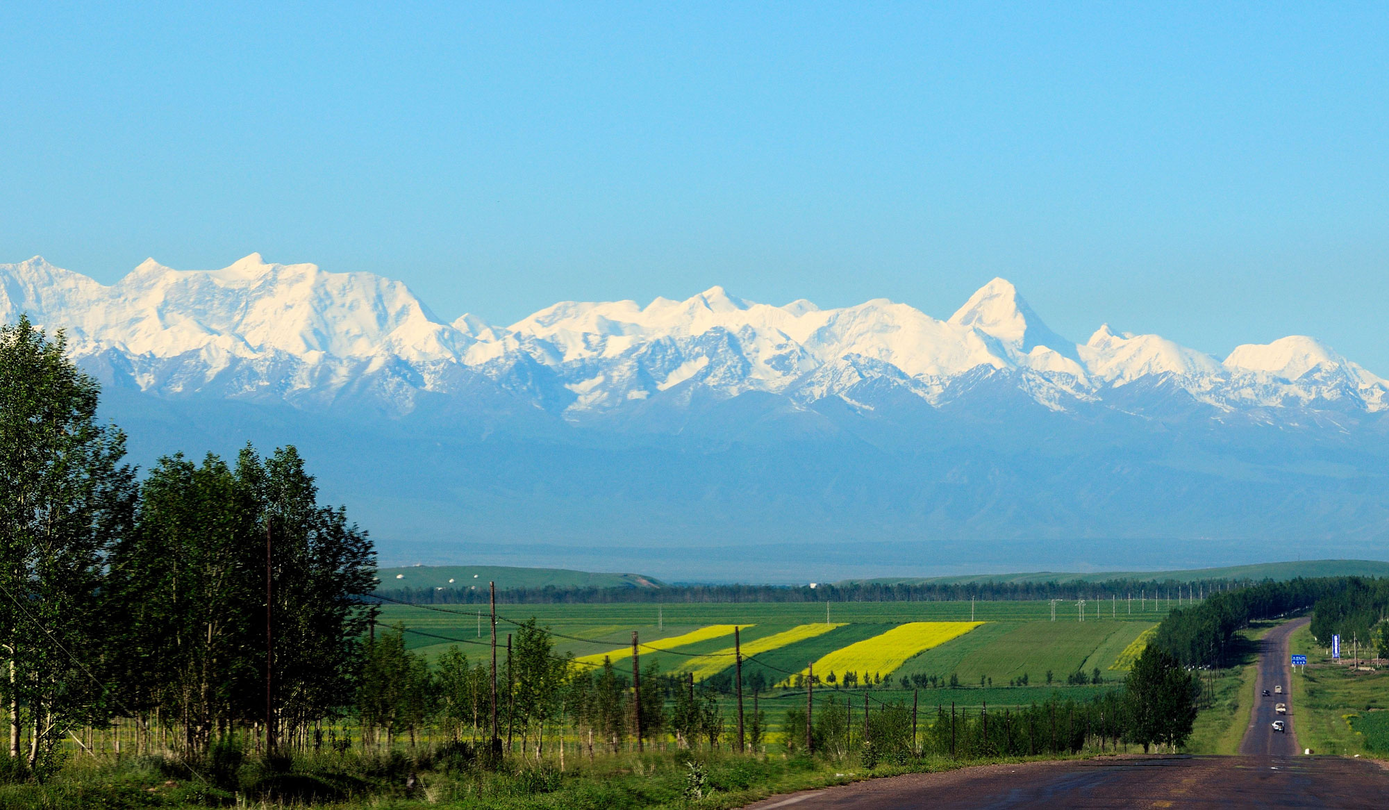
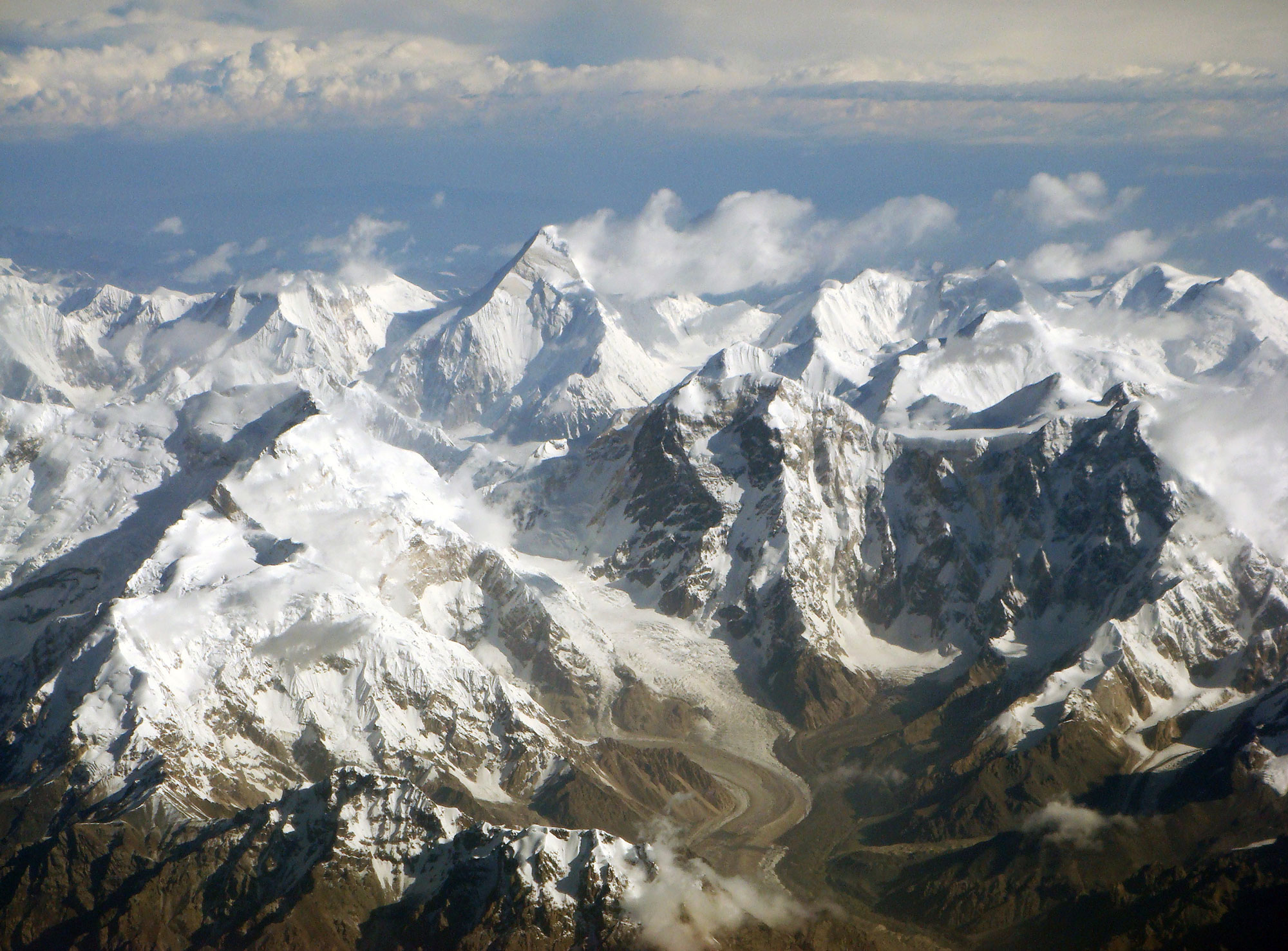
The Tianshan is a large mountain range in Central Asia stretching about 2,500 kilometers. It is the largest mountain chain in the world’s temperate arid region, and the largest isolated east-west mountain range globally. The Xinjiang portion of the Tianshan runs east-west for 1,760km and is a mountain range of outstanding natural beauty. The Xinjiang Tianshan is anchored in the west by the highest peak in the Tianshan, Tomur Peak at 7,443 meters, and in the east by Bogda Peak at 5,445 meters. The range lies between two Central Asian deserts, Junggar Desert in the north and the Tarim Desert in the south. The beauty of the Xinjiang Tianshan lies not only in its spectacular snow-capped mountains and glacier-capped peaks, beautiful forests and meadows, clear rivers and lakes and red bed canyons, but also in the combination and contrast between the mountain elements and the vast deserts. The stark difference of bare rocks on its south slope and luxuriant forest and meadow on the north creates a striking visual contrast of environments which are hot and cold, dry and wet, desolate and luxuriant – and of exceptional beauty.
Criterion (viii)
Xinjiang Tianshan is an outstanding example of ongoing biological and ecological evolutionary process in a temperate arid zone. The landforms and ecosystems have been preserved since the Pliocene epoch because of the Tianshan’s position between two deserts and its Central Asian arid continental climate, which is unique among the world's mountain ecosystems. Xinjiang Tianshan has all the typical mountain altitudinal zones of a temperate arid zone, reflecting the moisture and heat variations at different altitudes, gradients and slopes. The property is an outstanding example for the study of biological community succession in mountain ecosystems in an arid zone undergoing global climate change. Xinjiang Tianshan is also an outstanding representative of biological and ecological evolution in the Pamir-Tian Shan Highlands. Altitudinal vegetation distributions, significant differences between north and south slopes, and diversity of flora, all illustrate the biological and ecological evolution of the Pamir-Tian Shan Highlands. The property is also an important habitat for relic species, and numerous rare and endangered species, as well as endemic species. It is representative of the process whereby the original warm and wet flora has gradually been replaced by modern xeric Mediterranean flora.
Status
Xianjiang Tianshan is a World Heritage Site of grace and serenity with a majestic landscape. The serial property comprises of four components and all these four components lines the boundary of the property except Kalajun-Kuerdening, as this component includes two merged national parks. The heritage site’s border includes rivers, ridgelines and different vegetation zones and these factors benefit Xinjiang Tinshan acting as its natural defense against the threats. There are no industrial infrastructure developments, permanent inhabitants and even no records of invasive species within the property, this shows that the property faces very low degree threats. The heritage site is benefitted with a high level of legal protection as different components have different IUCN Categories conservation level, ranging from I-IV. Along with this, a management plan of the serial property as well as personal management plan of each component also exist and being implemented. The site is well funded and has no lack of staffs Coordination among components which face geographical barriers needs special attention for the effective management. Opportunities to increase the integrity of the property must be focused upon with the help of neighbors so that the property can become a transnational site (UNESCO 2013). A study conducted by Shi et al. 2019 showed that for the conservation and management of the property spatial zoning of the heritage site will be an important measure. The spatial zoning will help in revealing the heterogeneity of the different landscapes of the property at multiple levels. The study divided the property in five spatial divisions, Level 5 (Glacier dominated areas), Level 4 (lakes, glacial snow, meadows, grasslands, bare land of rich species diversity), Level 3 (region of high distribution of endangered and endemic species), Level 2 (temperate grasslands, degraded dry lands) and Level 1 (human settlement region) (Shi et al. 2019). The temperature and precipitation of the property has been increasing since the late 1980s and this change in precipitation and temperature is positively correlated with the runoff volume of rivers, lakes and is affecting the material balance of glaciers and ecology of the property. The study suggested that satellite-databased- calculation method might be new attempt for the evaluation of vegetation ecology in arid areas and its response towards climate change (Chen et al. 2005). The grazing practices and sedentarization of pastoralists is a concern that affects the property. Pastoralists traverse to ensure forage for their livestock and ensure their sustainability. The paper of __ focuses on the migration ofpastoralists of Tianshan and Atlay Mountains. Pastoralists of Atlay commute to places hundreds of kilometers far from their traditional lands while the Tianshan pastoralists choose migratory routes only dozens of kilometers away. Almost half of the pastoralists of Mount Tianshan commute during overwintering and summer while most of the Atlay pastoralists traverse based on the four season pattern. These foraging practices will lead to the degradation of the vegetation dynamics and ecosystem of the property. In order to avoid this, the administration should focus on developing effective and sustainable polices for pastors that will ensure that migration pattern does affect the vegetation dynamics and the long-established relationship of pastoralists and the ecosystem also remains undisturbed (Liao et al. 2013). According to the 2021 IUCN World Heritage Outlook (Xinjiang Tianshan, World Heritage Outlook (iucn.org)) assessed the property as ‘Good with some concerns’. Assessment reveals that the Outstanding Universal Value of the property has almost remained unchanged since the inscription and still manages to be in a good state. Growing tourism is emerging as a potential threat as with the increase in number of tourists, tourism related infrastructure is increasing which will lead to damage to the ecosystem of the property. The present management plan is quite effective but a new management plan with improved strategies is under process. The involvement of local stakeholders is still unclear though and this might an area of concern. The property filled with snowy and glacier capped mountains, climate change could be a potential concern for the glaciers. An integrated management plan for the entire property is not yet produced, although individual management plans of three components are in progress.