 The Willandra Lakes Region is a mixed
site, preserving the natural and cultural values of
the landscape. The site got its name from the relict
Willandra, the ecosystem of which ceased several
thousand years ago. The lake has evidence from the
Pleistocene epoch and is the best site for studying about
that period. The largest clay dunes of the world are
found here, as is a regional record of a Quaternary fossil
landscape, a resource for research into palae-oclimatic,
semi-arid environments and late Pleistocene palaeo-magnetism. There are several archaeological sites in
the area.
The Willandra Lakes Region is a mixed
site, preserving the natural and cultural values of
the landscape. The site got its name from the relict
Willandra, the ecosystem of which ceased several
thousand years ago. The lake has evidence from the
Pleistocene epoch and is the best site for studying about
that period. The largest clay dunes of the world are
found here, as is a regional record of a Quaternary fossil
landscape, a resource for research into palae-oclimatic,
semi-arid environments and late Pleistocene palaeo-magnetism. There are several archaeological sites in
the area.
The place is a land of extinct marsupials: the Tasmanian tiger, the giant short-nosed kangaroo, a Zygomaturus sp. and a Genyornis sp. The property is under the control of the New South Wales National Park and Wildlife Services. Protection of biodiversity to save the natural values and the cultural values of the park is a responsibility of the management board. The park is primarily managed under the Environment Protection and Biodiversity Conservation Act 1999, which provides the highest level of protection to the World Heritage properties of Australia. The IUCN World Heritage Outlook assessment categorised the site as in good condition with the lowest level of threats such as invasion by alien species and increasing tourism.
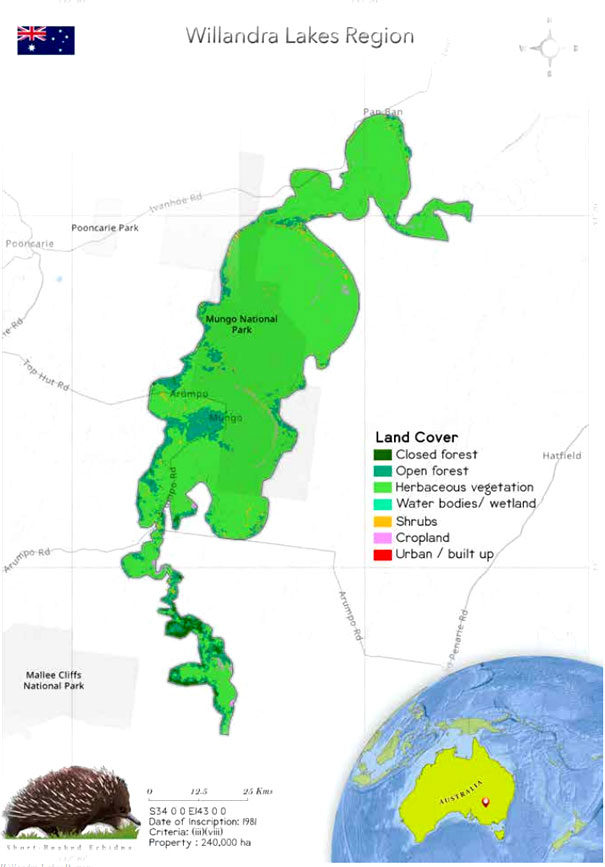
 The Willandra Lakes Region is located in
the Murray-Darling basin, in a semi-arid portion of
southwest New South Wales (Milne & O'NEILL1990;
Periodic reporting). The land comprises Tertiary marine
sediments, and aeolian sequences can be found in the
Pleistocene-age dunes and sand sheets. The property
has six major dry lakes and some depressions. The
basins have an extent of 1000 km2
. They are generally
interconnected and once held freshwater lakes (Milne &
O'NEILL 1990).
The Willandra Lakes Region is located in
the Murray-Darling basin, in a semi-arid portion of
southwest New South Wales (Milne & O'NEILL1990;
Periodic reporting). The land comprises Tertiary marine
sediments, and aeolian sequences can be found in the
Pleistocene-age dunes and sand sheets. The property
has six major dry lakes and some depressions. The
basins have an extent of 1000 km2
. They are generally
interconnected and once held freshwater lakes (Milne &
O'NEILL 1990).
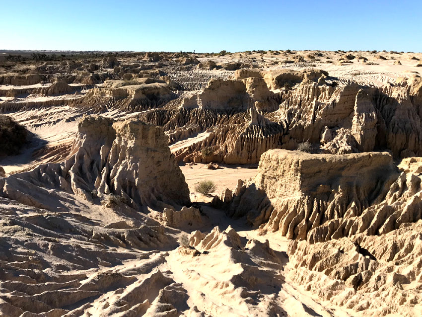
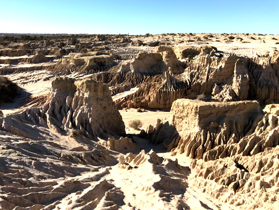
The region has a unique remnant lake. Its sediments, geomorphology and soil provide evidence that the lake was situated at a low altitude. The region also has non-glaciated Pleistocene landscapes. The lake is now in a ruminate form as its ecosystem was fragmented around 18,500 years ago. It is the best place to study the Pleistocene epoch. The area relates with the different stages of evolutionary history before and during the period of the last glacial maximum (Johnston & Mintern 2012) and from the Late Pleistocene period (IUCN Technical report 1987). The lake provides evidence of glacial-interglacial climatic oscillations that took place during the late Pleistocene period. The last interglacial cycle started around 130,000 years ago, as dated from fossil dunes, lake sediments and salinity fluctuations (IUCN Technical report 1987). The property has one of the largest clay dunes in the world, the Chibnalwood lunette. There are also many magnificent sites within the boundary of the property, such as the record of a regional Quaternary fossil landscape, which is a resource for research into palaeo-climatic semi-arid environments and late Pleistocene palaeo-magnetism.
The property has the largest group of Pleistocene archaeological sites of Australia. Almost 300 archaeological sites are located in the Willandra Lakes Region, and half of these sites are more than 10,000 years old. One can find simple artefacts in these sites as well as complex structures such as the 30-m thick deposits of the Lake Mungo Lunette (Hope 1985). The property is mainly a geological site, and its flora and fauna present are of specific interest as they connect with the archaeological sense. It was once a land of giant marsupials. These animals became extinct because of human predation.
 The drying up of the Willandra Lakes some 18,500
years BP allowed the survival of remarkable evidence of
the way early people interacted with their environment.
The undisturbed stratigraphy has revealed evidence of
Homo sapiens sapiens in this area from nearly 50,000
years BP, including the earliest known cremation, fossil
trackways, early use of grindstone technology and the
exploitation of fresh water resources, all of which provide
an exceptional testimony to human development during
the Pleistocene period.
The drying up of the Willandra Lakes some 18,500
years BP allowed the survival of remarkable evidence of
the way early people interacted with their environment.
The undisturbed stratigraphy has revealed evidence of
Homo sapiens sapiens in this area from nearly 50,000
years BP, including the earliest known cremation, fossil
trackways, early use of grindstone technology and the
exploitation of fresh water resources, all of which provide
an exceptional testimony to human development during
the Pleistocene period.
The Australian geological environment, with its low topographic relief and low energy systems, is unique in the longevity of the landscapes it preserves, and the Willandra Lakes provides an exceptional window into climatic and related environmental changes over the last 100,000 years. The Willandra Lakes, largely unmodified since they dried out some 18,500 years BP, provide excellent conditions for recording the events of the Pleistocene Epoch, and demonstrate how non-glaciated zones responded to the major glacial-interglacial fluctuations. The demonstration at this site of the close interconnection between landforms and pedogenesis, palaeochemistry, climatology, archaeology, archaeomagnetism, radiocarbon dating, palaeoecology and faunal extinction, represents a classic landmark in Pleistocene research in the Australasian area. Willandra Lakes Region is also of exceptional importance for investigating the period when humans became dominant in Australia, and the large species of wildlife became extinct, and research continues to elucidate what role humans played in these events.
 The property is managed by the New South
Wales (NSW) National Parks and Wildlife Services. The
Mungo National Park also comes under the boundaries
of the property which was 4.2% in the beginning but
got extended to 29.9% in 2012. The Willandra Lakes
Region Environmental Plan of New South Wales
had set up a statutory basis for management. Thus
groups such as the Community Management Council,
Technical and Scientific Advisory Committee, Elders
Council of Traditional Tribal Groups affiliated with the
Willandra region and Landholders Protection Group
can give advice on the management of the region.
The management plan for the site was framed in
consultation with all the stakeholders in 1989. When
the committee requested the state party to make a
management plan for the property (UNESCO, whc.
unesco.org), Peter Clark was contracted to assist (Hope
1985.
The property is managed by the New South
Wales (NSW) National Parks and Wildlife Services. The
Mungo National Park also comes under the boundaries
of the property which was 4.2% in the beginning but
got extended to 29.9% in 2012. The Willandra Lakes
Region Environmental Plan of New South Wales
had set up a statutory basis for management. Thus
groups such as the Community Management Council,
Technical and Scientific Advisory Committee, Elders
Council of Traditional Tribal Groups affiliated with the
Willandra region and Landholders Protection Group
can give advice on the management of the region.
The management plan for the site was framed in
consultation with all the stakeholders in 1989. When
the committee requested the state party to make a
management plan for the property (UNESCO, whc.
unesco.org), Peter Clark was contracted to assist (Hope
1985.
The site faces threats from alien species (feral animals such as rabbits and goats) and weeds. The rabbits and goats are posing a threat by overgrazing. Tourism to the site is increasing, which can cause severe damage to the property if it is not managed properly (IUCN World Heritage Outlook 2020). The State of Conservation Report 1995 expresses concerns about issues such as the landowner residents, aboriginal concerns and the making of a management plan. The boundaries of the property need to be revised, the total area needs to be reduced, and some small parts are to be added. The revision of the boundary is probably going to implicit the cultural and natural values. The management and protection of the park is effective. The land was previously occupied by pastoral stations, but now most of the site is Crown lands of the New South Wales Department of Planning, Industry and Environment.
Overall, the management of the park is in good condition, and the cultural and natural values of the site are intact. Issues such as the increase in the numbers of feral animals and the pressure of overgrazing on the vegetation needs to be addressed through a long-term plan (IUCN World Heritage Outlook 2020).