 Uluru-Kata Tjuta National Park is a mixed
Heritage Site located at the southwestern end of
Northern Australia. It presents is an amalgam of natural
beauty and a cultural history of millions of years. Uluru
is a gigantic sandstone rock that stands 348 m high. The
landscape is arid or semi-arid, with topographic features
unique to deserts such as dune fields and sandplains.
The vegetation is scanty: only a few species of tree are
present, namely, mulga (Acacia aneura), thryptomene,
spinifex and desert bloodwoods. The site is managed
by the Uluru-Kata Tjuta Board of Management and
Parks Australia. However, the indigenous people of
the Anangu community are the keys in the Park's
management. There have been incidence of wildfires
in the park. The fires were caused either naturally or
by anthropogenic activities. The buffer zone of this
heritage property is being affected by an invasion
of buffel grass.
Uluru-Kata Tjuta National Park is a mixed
Heritage Site located at the southwestern end of
Northern Australia. It presents is an amalgam of natural
beauty and a cultural history of millions of years. Uluru
is a gigantic sandstone rock that stands 348 m high. The
landscape is arid or semi-arid, with topographic features
unique to deserts such as dune fields and sandplains.
The vegetation is scanty: only a few species of tree are
present, namely, mulga (Acacia aneura), thryptomene,
spinifex and desert bloodwoods. The site is managed
by the Uluru-Kata Tjuta Board of Management and
Parks Australia. However, the indigenous people of
the Anangu community are the keys in the Park's
management. There have been incidence of wildfires
in the park. The fires were caused either naturally or
by anthropogenic activities. The buffer zone of this
heritage property is being affected by an invasion
of buffel grass.

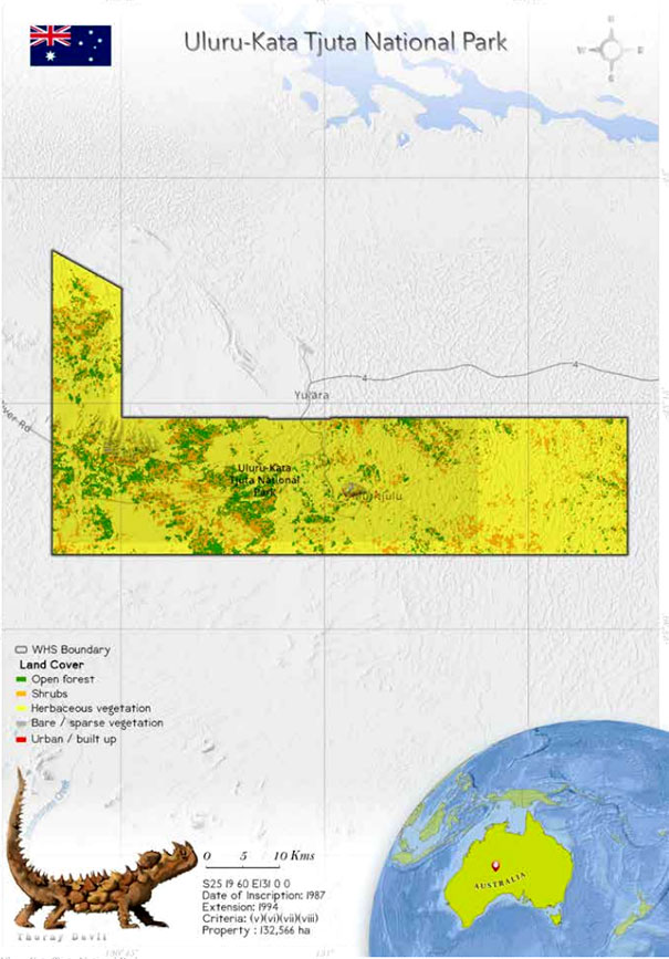
 Uluru-Kata Tjuta National Park (UKTNP) is a mixed
World Heritage Site. It was primarily listed as a Natural
Heritage Site in 1987, and in 1994, it was reinscribed as a
Mixed Site (UNESCO whc.unesco.org). The national park
is valued for both its cultural landscape and its biological
values. It is also a designated biosphere seserve (Gillen
et al. 2000).
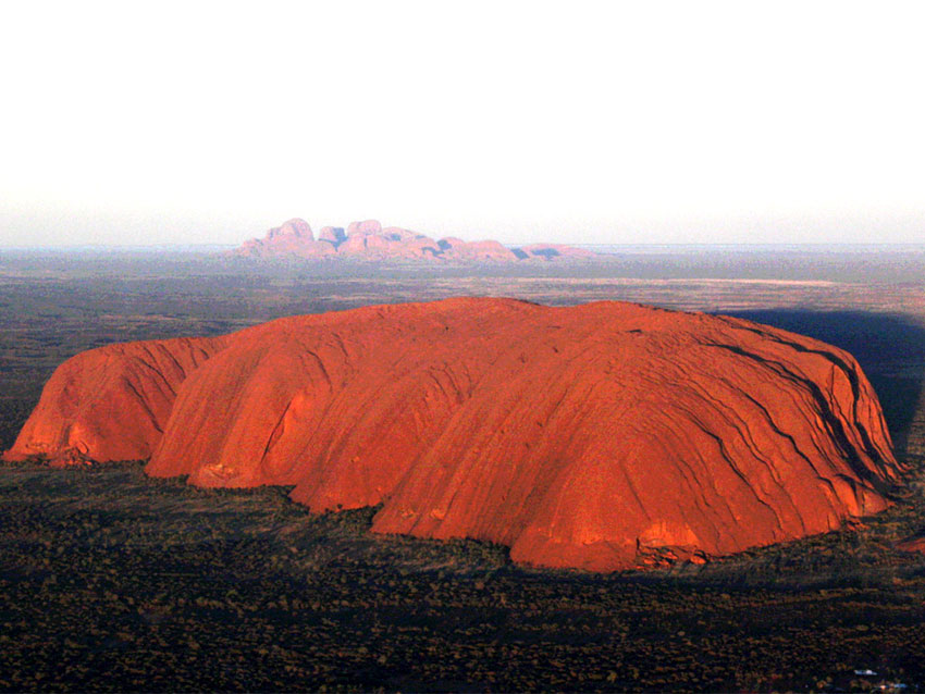
Uluru is a massive sandstone rock started forming
680 million years. It stands 348 m high, and the
conglomerate domes of Kata Tjuta rise up to 500 m
(Uluru-Kata Tjuta Board of Management and Parks
Australia 2000).
Uluru-Kata Tjuta National Park (UKTNP) is a mixed
World Heritage Site. It was primarily listed as a Natural
Heritage Site in 1987, and in 1994, it was reinscribed as a
Mixed Site (UNESCO whc.unesco.org). The national park
is valued for both its cultural landscape and its biological
values. It is also a designated biosphere seserve (Gillen
et al. 2000).
Uluru is a massive sandstone rock started forming
680 million years. It stands 348 m high, and the
conglomerate domes of Kata Tjuta rise up to 500 m
(Uluru-Kata Tjuta Board of Management and Parks
Australia 2000).
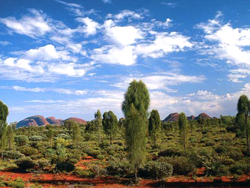
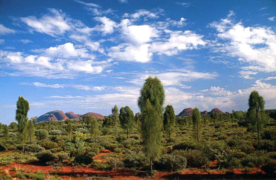
The Uluru rock changes colour , from dark purple to golden, during the day (Astanin 2019). UKTNP is situated within the Amadeus Basin (English 1998a, Sweet and Crick 1992). It is classified as a semi-arid to arid landscape, and it is located in the southwestern corner of Australia's Northern Territory (Reid et al. 1993; Dittmer 2016). Uluru and Kata Tjuta are the prominent topographic structures in the landscape, but the rest of the park is covered with dune fields and sandplains (English 1998a, Johnson & Burbidge 2008, Reid et al. 1993; Uluru-Kata Tjuta Board of Management and Parks Australia 2000).
 The dunes can reach heights of up to 13 m (Sweet and
Crick 1992). Clay-rich red earths and dune swales are
found across the greater park in the outwash areas of Uluru and Kata Tjuta. It is said that UKTNP is a treasure
chest of ancient rock paintings. The site showcases
the socio-cultural heritage of the Anangu community
(Astanin 2019).
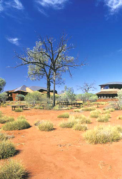
In the buffer zone, the dominant plants are mulga
trees (Acacia aneura), shrubs of the genera Ptilotus and
Senna and the invasive buffel grass (Cenchrus ciliaris).
The habitat at the base of Uluru comprises patchy
stands of bloodwood trees (Corymbia terminalis) or
areas of Themeda grasses and buffel grass (Dittmer
2016).
The dunes can reach heights of up to 13 m (Sweet and
Crick 1992). Clay-rich red earths and dune swales are
found across the greater park in the outwash areas of Uluru and Kata Tjuta. It is said that UKTNP is a treasure
chest of ancient rock paintings. The site showcases
the socio-cultural heritage of the Anangu community
(Astanin 2019).
In the buffer zone, the dominant plants are mulga
trees (Acacia aneura), shrubs of the genera Ptilotus and
Senna and the invasive buffel grass (Cenchrus ciliaris).
The habitat at the base of Uluru comprises patchy
stands of bloodwood trees (Corymbia terminalis) or
areas of Themeda grasses and buffel grass (Dittmer
2016).
Overall, the habitats around the base of Uluru are distinct from the spinifex sandplains and sand dunes that dominate the rest of the UKTNP lands (Reid et al. 1993). UKTNP receives an average of 290 mm of rain annually. Most of the rainfall is in the warmer months, occurring in patches across the desert landscape (Reid et al. 1993). The temperature is quite predictable in the national park (Reid et al. 1993). The summers are hot during the day and milder at night, with an average temperature of 400C between October and April (Bureau of Meteorology 2017). Typically, winters have cold nights, with occasional frost (Bureau of Meteorology 2011; Reid et al. 1993).
The biodiversity of UKTNP displays eccentric endemism, with consistent floristic patterns within the park's sand-dune and sandplain habitats (Buckley 1981). The dune crests have fairly sparse vegetation. The midslopes of the dunes have a dense cover of thryptomene (Aluta maisoneuveii) (Buckley 1981, English 1998b), whereas the dominant species on the lower dune slopes is spinifex (Triodia spp.). The clayey sands of the outer swales sustain tussocks (Buckley 1981).
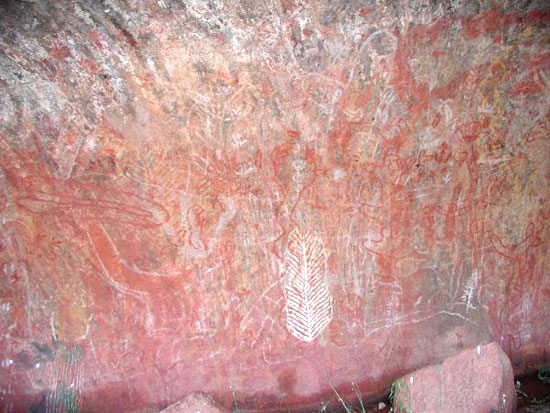 The cultural landscape of Uluru-Kata Tjuta National
Park is an outstanding living reflection of indigenous
Anangu traditional hunting, gathering and other
practices of great antiquity that have created an intimate
relationship between people and their environment.
The cultural landscape of Uluru-Kata Tjuta National
Park is an outstanding living reflection of indigenous
Anangu traditional hunting, gathering and other
practices of great antiquity that have created an intimate
relationship between people and their environment.
The cultural landscape is of outstanding significance for the way it is perceived as the creation of Mala, Lungkata, Itjaritjari, Liru and Kuniya - these are heroic ancestral beings of the Tjukurpa. The landscape isread as a text specifying the relationship between the land and its Indigenous inhabitants, as laid down by the Tjukurpa. The monoliths of Uluru and Kata Tjuta are seen as living proof of the heroes' actions and their very being.
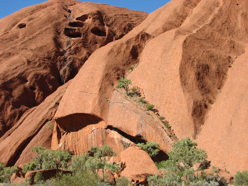
The huge monolith of Uluru and multiple rock domes of Kata Tjuta (32 kilometres to the west of Uluru) have outstanding scenic grandeur, contrasting with each other and the surrounding flat sand plains.
The monolithic nature of Uluru is emphasised by sheer, steep sides rising abruptly from the surrounding plain, with little or no vegetation to obscure the silhouette. The exceptional natural beauty of the Uluru-Kata Tjuta National Park landscape is also of cultural importance to Anangu.
The inselbergs (steep-sided isolated hills rising abruptly from the earth) of Uluru and Kata Tjuta are outstanding examples of tectonic, geochemical and geomorphic processes. Uluru and Kata Tjuta reflect the age, and relatively stable nature, of the Australian continent.Uluru and Kata-Tjuta demonstrate ongoing geological processes of remarkable interest. The sides of Uluru are marked by a number of unusual features which can be ascribed to differing processes of erosion. For example, the colossal geological feature described as Ngaltawata, a ceremonial pole associated with Mala Tjukurpa, is ascribed to sheeting of rock parallel to the existing surface. During rain periods, the runoff from Uluru cascades down the fissures forming waterfalls, some up to 100 metres high. Caves at the base of Uluru are formed by a widespread arid zone process of granular disintegration known as cavernous weathering
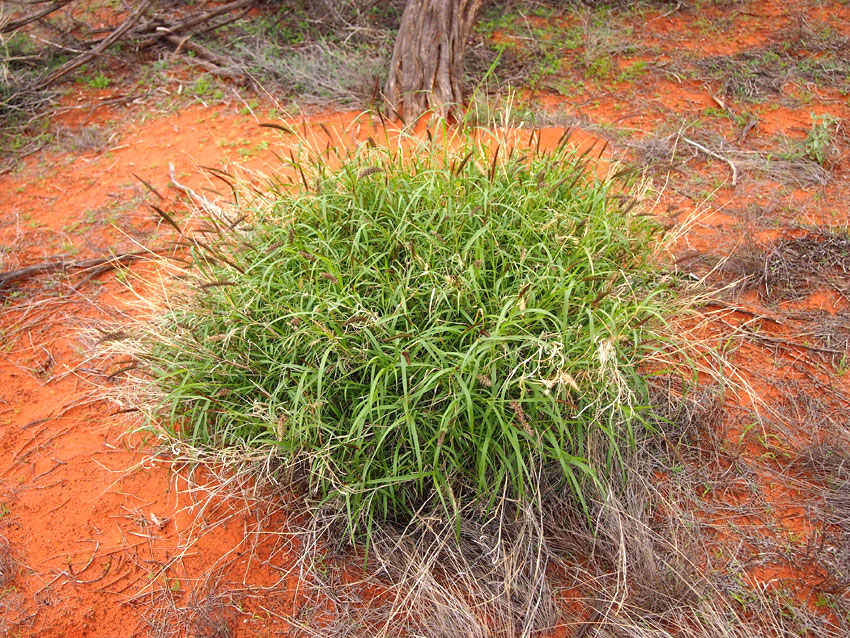
 At present, UKTNP has not encountered severe
threats. However, there is the concern of invasion by
buffel grass (Cenchrus ciliaris), which it is believed will
impact the endemic biodiversity. It is also believed that
the grass poses a wildfire threat close to Uluru and
along creeklines and roadsides at Kata Tjuta (Dittmer
& Bidwell 2017). Buffel grass was introduced in the
national Park in the late 1960s as an erosion control
measure (Uluru Kata Tjuta Board of Management 1991).
Buffel grass grows in the same habitat as do native
Themada grasses, i.e., mesic soils (Lunt et al. 2012;
Marshall et al. 2012).
At present, UKTNP has not encountered severe
threats. However, there is the concern of invasion by
buffel grass (Cenchrus ciliaris), which it is believed will
impact the endemic biodiversity. It is also believed that
the grass poses a wildfire threat close to Uluru and
along creeklines and roadsides at Kata Tjuta (Dittmer
& Bidwell 2017). Buffel grass was introduced in the
national Park in the late 1960s as an erosion control
measure (Uluru Kata Tjuta Board of Management 1991).
Buffel grass grows in the same habitat as do native
Themada grasses, i.e., mesic soils (Lunt et al. 2012;
Marshall et al. 2012).
The authorities have relied on certain eradication strategies to remove buffel grass, such as hand-pulling and herbicide control (Eyre et al. 2009; Director of National Parks 2010; Marshall et al. 2012; IUCN 2020). Other weeds that are likely to disperse at the site include khaki weed (Alternanthera pungens), Mexican poppy (Argemone ochroleuca), Mossman River grass (Cenchrus echinatus), caltrop (Tribulus terrestris) and couch grass (Cynodon dactylon) (DoE 2013; Freidel et al 2006; NRETAS, 2013).
Due to the prevailing arid conditions, wildfires are caused by traditional management practices of the Anangu and the park staff. The indigenous people use patch-burning methods in the management of the park (DoNP 2010). Natural wildfires occur after heavy rainfall events, when the vegetation grows profusely, after which it decays. This results in generation of large quantities of fuel that is prone to catching fire (IUCN World Heritage Committee 2020).
In the 2020 IUCN Conservation Outlook Assessment, UKTNP has been assessed as "good".