Trang An Landscape Complex (1438)
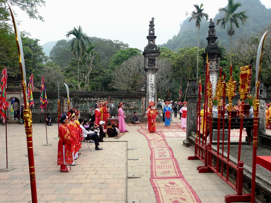
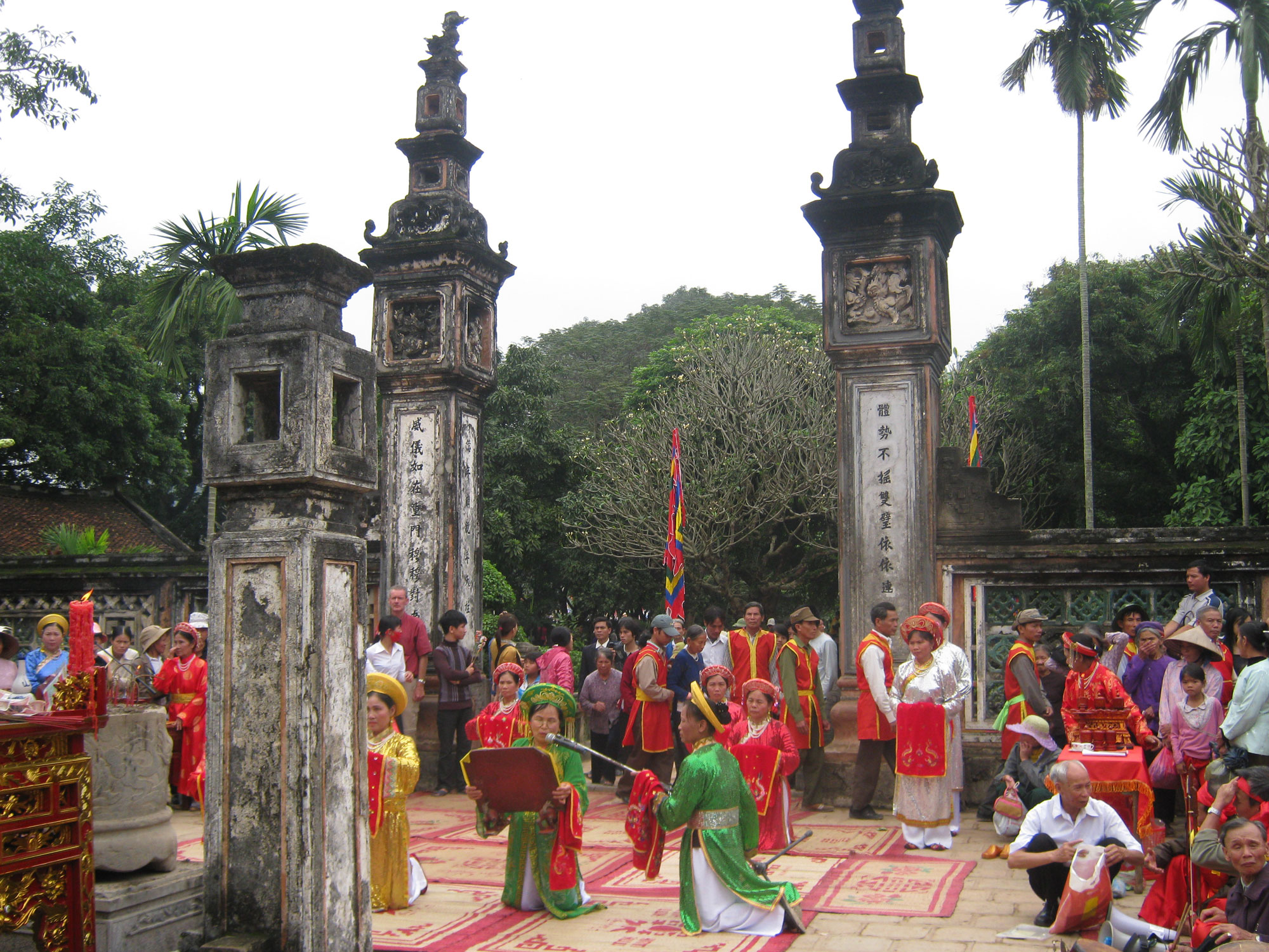
 The Trang An Landscape Complex is a mixed site, having natural as well as cultural entities. It is located along the southern margin of the Red River Delta. The area has a limestone karst landscape along with valleys and cliffs, which make an exceptionally spectacular landscape, making it a World Heritage Site under the natural criteria. An archaeological survey has found evidence of human activities more than 30,000 years back at the site. The ancient humans were hunter-gatherers, and the place signifies how they adapted to the climatic and environmental changes. These factors make the site a Cultural World Heritage Site. The stories of ancient human occupation are from the Neolithic and Bronze Ages. Various temples, paddy fields, pagodas and small villages add beauty to the property. A public-private partnership manages the property, and the Trang An Landscape Complex Management Board controls activities such as protection, tourism activities, commercial activities and sustainable socio-economic development. The management board and the direct association with government ministries, research institutes, and commercial and community stakeholders manage the property. The property is a very famous destination, and there are two segments of visitors: those who visit the site because of its natural beauty and pilgrims, who visit the site during festivals. Increasing tourism might be a cause for concern in the coming days; however, tourism does help in the improvement of the economy by providing different occupations to the locals in different tourism services.
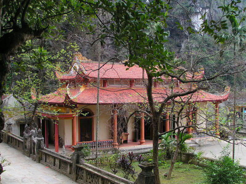
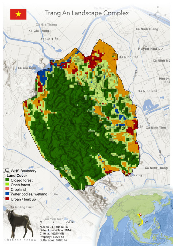
 The Trang An Landscape is a mixed World Heritage Site. The property is situated in Ninh Binh Province, of North Vietnam, near the southern margin of the Red River Delta and is 90 km south-east of the capital, Hanoi. It comprises three protected areas: the Hoa Lu Ancient Capital, which has an extent of 314 ha, the Trang An–tam Coc-Bich Dong Scenic Area (2483 ha) and the Hoa Lu Special-Use Primary Forest (3375 ha) (Le & Bui 2019). The property has mountains of limestone. The area of the buffer zone is 6026 ha, and there are around 14,000 inhabitants. The people here are involved in agriculture and own rice paddy fields (UNESCO whc.unesco.org). The area is a famous cultural, natural, and pilgrimage tourist destination of Vietnam (Le & Bui 2019).
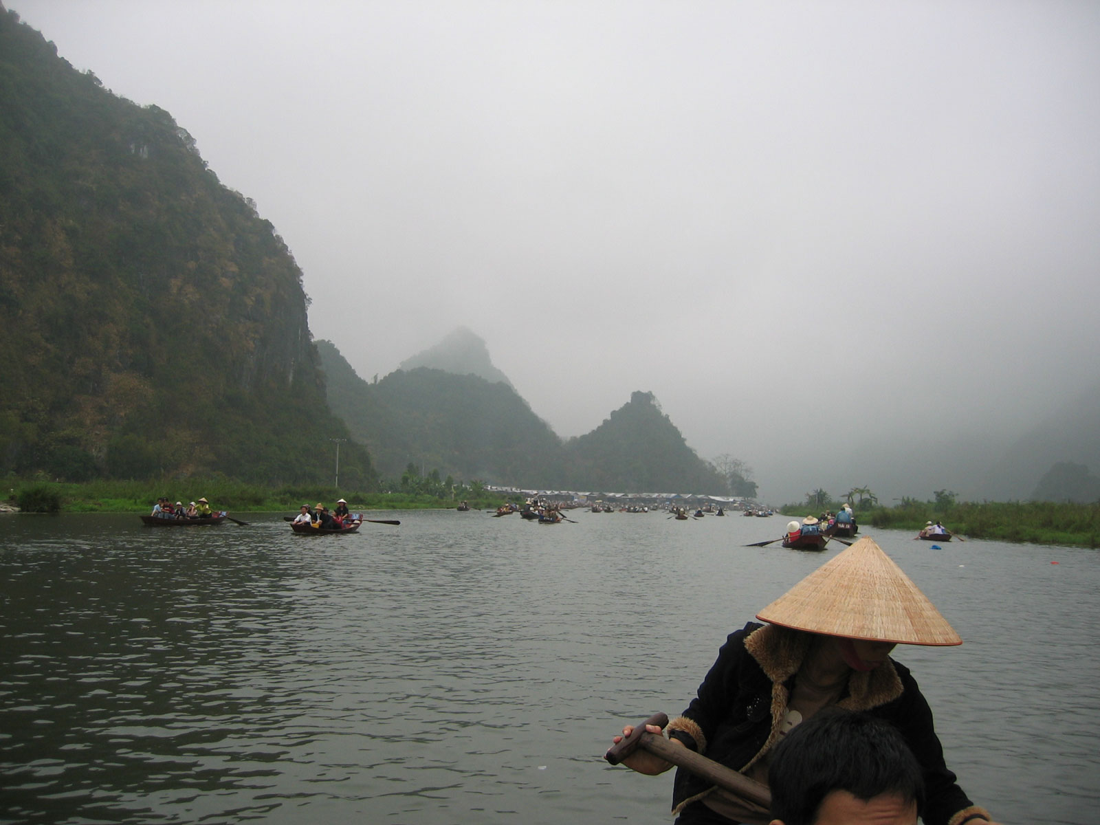
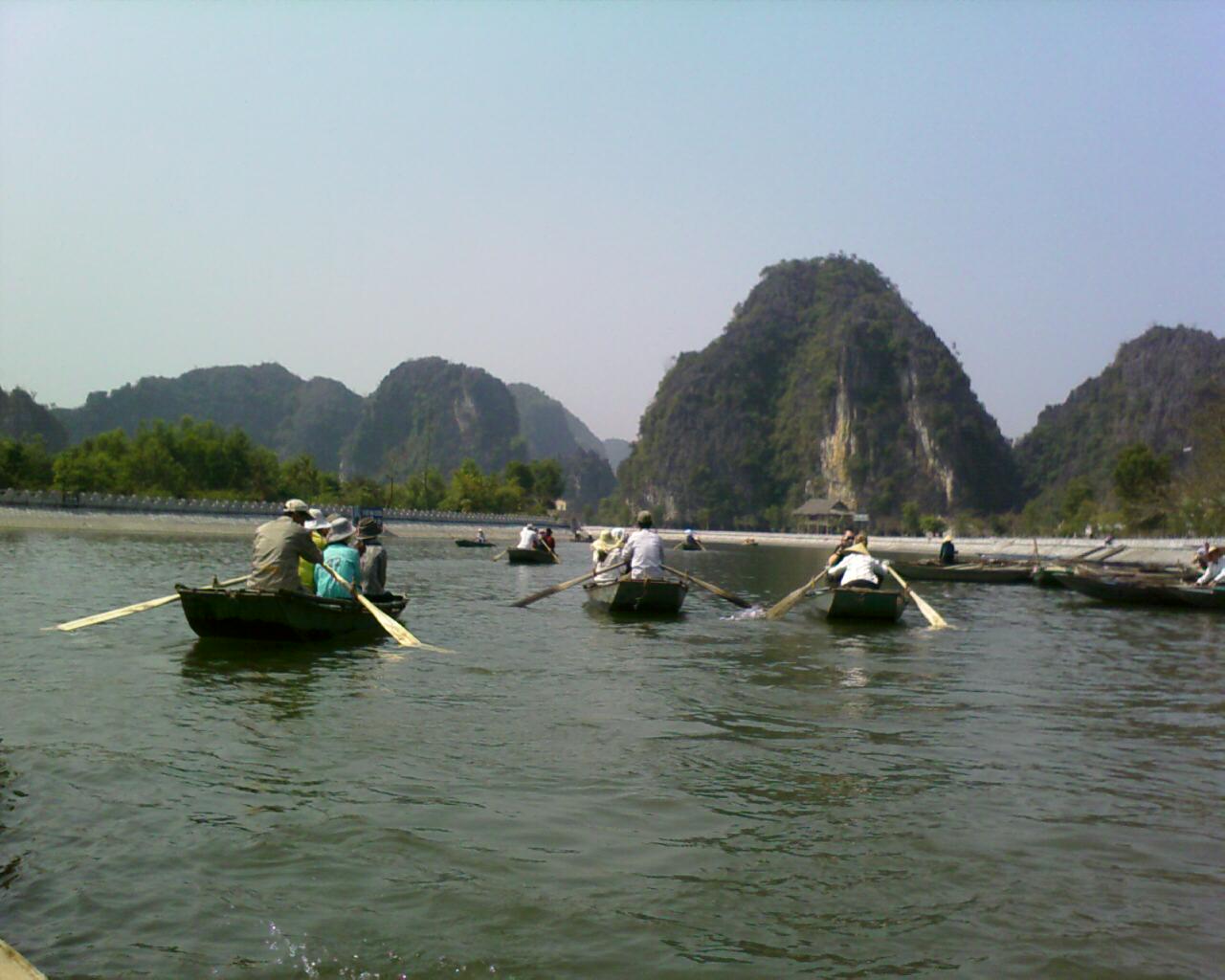
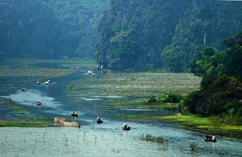
The site is known for its karst ranges, flooded valleys and interconnected cave systems, through which visitors can undertake tours on boats. The Hoa Lu Ancient Capital is the first kingdom of Viet Nam (Nguyen et al. 2018). The advisory body ICOMOS has reported that Hoa Lu was ascertained in the 10th and 11th centuries AD.
The Trang An Landscape has a distinct physical appearance with valleys between limestone karst peaks. The area has subterranean waterways that connect the karst cones and towers. The cultural aspect of the property lies in evidence of the ancient inhabitants and their culture and relationship with the landscape. The archeological excavations and investigations have resulted in findings of shells, animal bones, stone tools, hearths, corded-ware pottery and some human remains.
Modern technologies such as geochemical analysis of plant carbon isotopes and lipids and shell oxygen isotopes and the pioneering use in Southeast Asia of LiDAR (Light Distancing and Ranging) have proved the presence of palaeo-environment records through analysis of pollen, seeds and plant tissues (UNESCO whc.unesco.org).
An archaeological survey found evidence of human activities dating back more than 30,000 years. It was shown that the occupation of these men was from the Neolithic and Bronze Ages (Advisory Body Evaluation ICOMOS 2016). Now the landscape is in the final stages of geomorphic evolution (UNESCO whc.unesco.org). UNESCO has also reported that the area was covered by the sea many times in recent geological history, but now it has emerged.
The Trang An Landscape is a mixed World Heritage Site. The property is situated in Ninh Binh Province, of North Vietnam, near the southern margin of the Red River Delta and is 90 km south-east of the capital, Hanoi. It comprises three protected areas: the Hoa Lu Ancient Capital, which has an extent of 314 ha, the Trang An–tam Coc-Bich Dong Scenic Area (2483 ha) and the Hoa Lu Special-Use Primary Forest (3375 ha) (Le & Bui 2019). The property has mountains of limestone. The area of the buffer zone is 6026 ha, and there are around 14,000 inhabitants. The people here are involved in agriculture and own rice paddy fields (UNESCO whc.unesco.org). The area is a famous cultural, natural, and pilgrimage tourist destination of Vietnam (Le & Bui 2019).
The site is known for its karst ranges, flooded valleys and interconnected cave systems, through which visitors can undertake tours on boats. The Hoa Lu Ancient Capital is the first kingdom of Viet Nam (Nguyen et al. 2018). The advisory body ICOMOS has reported that Hoa Lu was ascertained in the 10th and 11th centuries AD.
The Trang An Landscape has a distinct physical appearance with valleys between limestone karst peaks. The area has subterranean waterways that connect the karst cones and towers. The cultural aspect of the property lies in evidence of the ancient inhabitants and their culture and relationship with the landscape. The archeological excavations and investigations have resulted in findings of shells, animal bones, stone tools, hearths, corded-ware pottery and some human remains.
Modern technologies such as geochemical analysis of plant carbon isotopes and lipids and shell oxygen isotopes and the pioneering use in Southeast Asia of LiDAR (Light Distancing and Ranging) have proved the presence of palaeo-environment records through analysis of pollen, seeds and plant tissues (UNESCO whc.unesco.org).
An archaeological survey found evidence of human activities dating back more than 30,000 years. It was shown that the occupation of these men was from the Neolithic and Bronze Ages (Advisory Body Evaluation ICOMOS 2016). Now the landscape is in the final stages of geomorphic evolution (UNESCO whc.unesco.org). UNESCO has also reported that the area was covered by the sea many times in recent geological history, but now it has emerged.
Criterion (v)
 Trang An is an outstanding locale within Southeast Asia, for demonstrating the way early humans interacted with the natural landscape and adapted to major changes in climatic, geographical and environmental conditions over a period of more than 30,000 years. The long cultural history is closely associated with geological evolution of the Trang An limestone massif in late Pleistocene and early Holocene times, when the inhabitants endured some of the most turbulent climatic and environmental changes in Earth history, including repeated submergence of the landscape due to oscillating sea levels. Within the one compact landscape there are many sites covering multiple periods and functions, comprising early human settlement systems.
Criterion (vii)
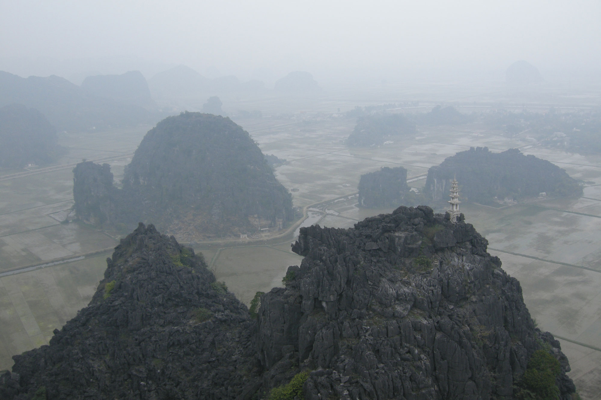
The exceptionally beautiful tower-karst landscape of Trang An is dominated by a spectacular array of forest-mantled limestone rock towers up to 200m high, which are linked in places by sharp ridges enclosing deep depressions filled by waterways that are inter-connected by a myriad of subterranean cave passages. These features all contribute to a multi-sensory visitor experience that is heightened by contrasting and ever-changing colours – the deep green tropical rainforests, grey limestone rocks and cliffs, blue-green waters and the brilliant blue of the sky, and areas of human use including the green and yellow rice paddies. Visitors, conveyed in traditional sampans rowed by local guides, experience an intimate connection with the natural environment and a relaxing sense of serenity and security. The dramatic mountains, secretive caves and sacred places in Trang An have inspired people through countless generations.
Criterion (viii)
Trang An is a superb geological property that displays, in a globally exceptional way, the final stages of tower-karst landscape evolution in a humid tropical environment. Deep dissection of an uplifted limestone massif over a period of five million years has produced a series of classical karst landforms, including cones, towers, enclosed depressions (cockpits), interior-draining valleys (poljes), foot- caves and subterranean cave passages decorated with speleothems. The presence of transitional forms between 'fengcong' karst with ridges connecting towers, and 'fenglin' karst where towers stand isolated on alluvial plains, is an extremely significant feature of the property. Trang An is an unusual autogenic karst system, being rain-fed only and hydrologically isolated from rivers in the surrounding terrain. Former inundation by the sea transformed the massif into an archipelago for some periods, though it is fully emergent on land today. Fluctuations of sea level are evidenced by an altitudinal series of erosion notches in cliffs, with associated caves, wave-cut platforms, beach deposits and marine shell layers.
Status
The property is managed by a public–private partnership (PPP). The public body is the Ninh Binh Provincial People’s Committee. The private body is the Xuan Truong Corporation (Nguyen et al. 2018). The property is under the control of the public body, the committee, and work such as conservation, forest restoration and tourism activities is managed by the corporation’s private unit. There are six primary national laws and a series of government decrees that govern activities such as the administration and management of the property, protection of cultural heritage and monuments, eco-tourism, commercial activities and sustainable socio-economic development. The property is under the control of the Trang An Landscape Complex Management Board, and it has a direct association with government ministries, research institutes and commercial and community stakeholders (UNESCO whc.unesco.org).
As a famous destination, it is a considerable tourist attraction. In 2016, there were 2.4 million tourists, 11% more than in the previous year. In 2020, it was estimated that there would be 2 to 3.5 million visitors (State of Conservation Report 2014). Tourism is most intense from March to May, the first three months of the Lunar New Year. Pilgrims visit the place during this is festival time. The tourism is relatively low in the remaining nine months. The mode of transportation along waterways is by traditional-style sampans rowed by local people (Le & Bui 2019). However, according to the State of Conservation report of 2018, there are no considerable environmental or social impacts due to the increasing tourism. Tourism is also playing an essential role in lifting the economy of the area. The local people who depended on agriculture and handicrafts are now getting involved in tourism services such as boating, hotels, homestays, photography, tour guiding, etc. It has been reported that in the last ten years, from 2010 to 2019, there has been a 26% growth in the participation of labour directly or indirectly in the tourism services (Mai & Quan 2020).
According to the State of Conservation Report 2014, the State Party reports to the committee about the revision of the management plan, which will focus more on the archaeological heritage and number of visitors, emphasizing the protection of prehistoric archaeological sites, research, conservation, capacity-building and training. More boats have been provided to the local State Party, with more boat trips daily and some new boat routes to support the increasing number of visitors to the World Heritage Site. The project SUNDASIA deals with research on prehistoric communities and conducts biodiversity surveys. The management of the World Heritage site is efficient, and there are no significant threats to the Outstanding Values of the property, according to the IUCN World Heritage Outlook 2020. However, increasing tourism may cause concerns in the future. The property has two different visitor segments: visitors who visit the site and appreciate the OUV of the property (with an emphasis on its natural landscape) and religious pilgrims. Thus, a management plan should be made that considers both these segments. The paddy fields and rural dwellings provide a unique, exceptional beauty to the landscape. Tourism is increasing, and this has not had a great impact on the site. However, the development of infrastructure and provision of services due to the increasing tourism might be dangerous for the site in the future (IUCN World Heritage Outlook 2020).