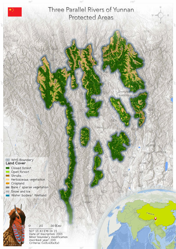
Three Parallel Rivers of Yunnan Protected Areas (1083)
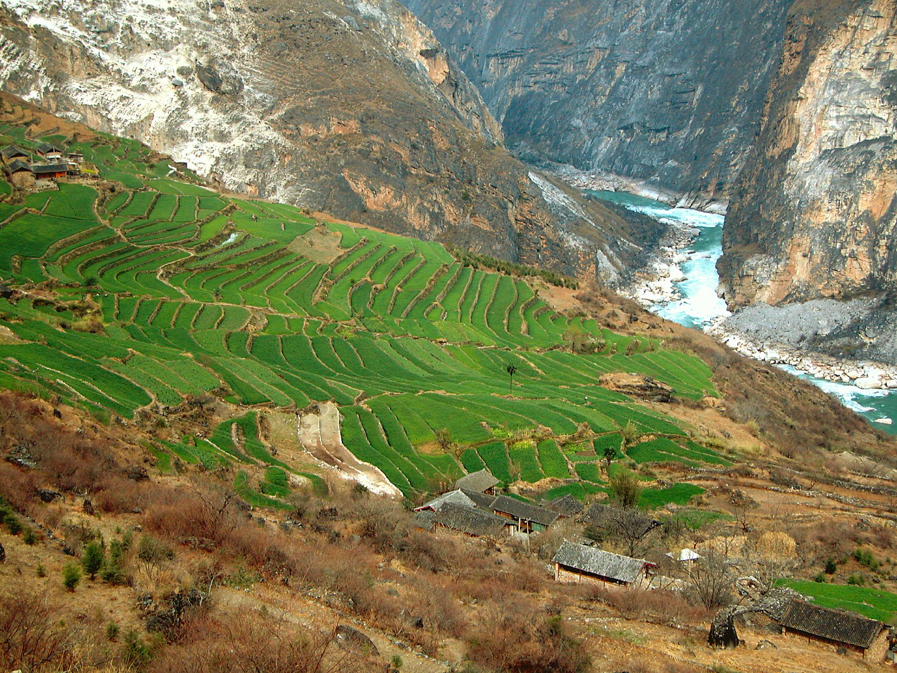
 The mountainous Three Parallel Rivers of Yunnan is a cluster of eight geographical regions. The property features the three great rivers of Asia, namely, the Yangtze, Mekong and Salween. These three rivers run roughly parallel to each other and give the World Heritage Site its name. The property is a mixture of gorges that are as deep as 3000 m and glaciated peaks rising above 6000 m. The scenic area has China’s richest biodiversity and is known as the epicentre of the biodiversity. The property was inscribed as a UNESCO Natural World Heritage Site in 2003. The heritage site is home to web-footed water shrew (Nectogale elegans), endemic Yunnan snub-nosed monkey (Rhinopithecus bieti), Assam macaque (Macaca assamensis), red panda (Ailurus fulgens), clouded leopard (Neofelis nebulosa), Chinese grouse (Bonasa sewerzowi), Sclater's monal pheasant (Lophophorus sclateri), black-necked crane (Grus nigricollis), whitespeckled laughing thrush (Garrulax bieti), etc. The management and conservation of this vast serial property is a task in its own right, and the State Party has taken extraordinary steps to protect the Outstanding Universal Value of the inscribed property. A plan to develop hydropower dams within the property has been halted as the scheme would have negatively affected the OUV of the site. Some dams are proposed outside the property, and the World Heritage Committee is concerned about this. But the State Party has given the assurance that it will take major steps to protect the OUV of the heritage site.
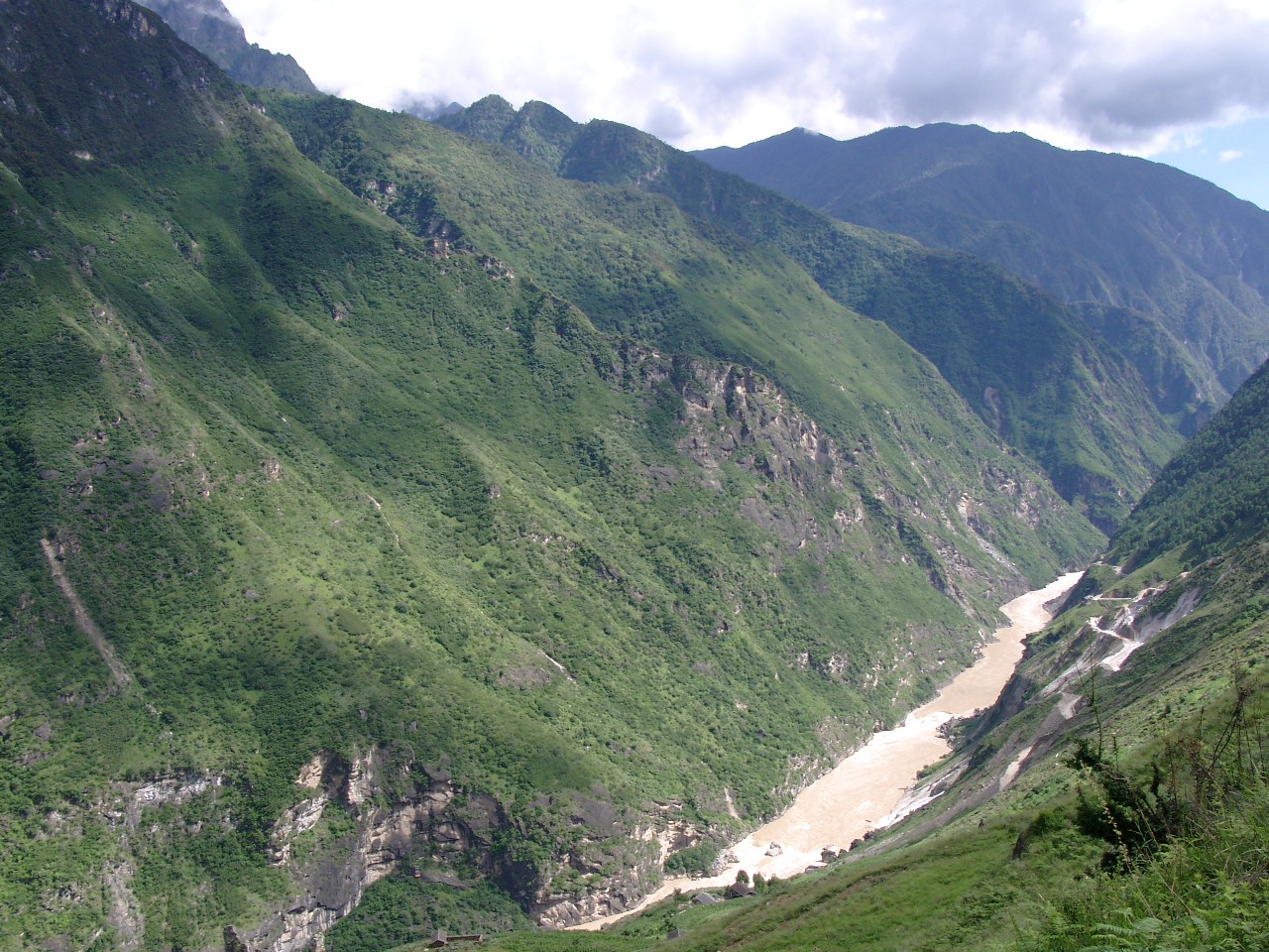
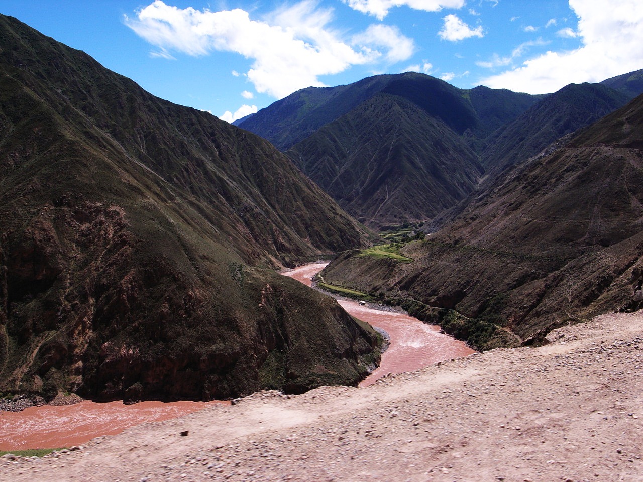
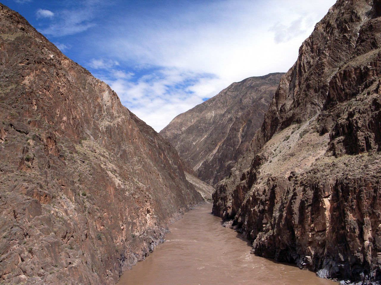
 The lofty mountains of northwest Yunnan Province form a natural landscape known as the Three Parallel Rivers of Yunnan Province. The site was inscribed as a UNESCO World Heritage Site in 2003. The natural heritage site comprises 15 protected areas clustered in eight geographical regions. The landscape was named Three Parallel Rivers because the three great rivers of East Asia, namely the Jinsha River (the upper reaches of the Yangtze River), the Lancang River (the upper reaches of the Mekong River) and the Nujiang River (the upper reaches of the Salween River) flow in the north–south direction parallel to each other through the Gaoligong Mountains, Yunling Mountains, Dandanlika Mountains, Mount Fury and other mountains (Rong2017).
The Indian summer monsoon brings humid air with 80% or more precipitation; winters are generally dry and cold (Cheng et al 2018). According to Cheng, the vegetation of the Three Parallel Rivers region differs by niche along the altitudinal gradient, and this is a prominent aspect of the vegetation of the site. Cheng also divided the vegetation of the Three Parallel Rivers region into five categories: Savanna (1900-3000m), Coniferous and Broad-Leaved Mixed Forests (3000–3800 m), Abies (3800–4100 m), Alpine Shrubs (4000–4350 m) and Alpine Meadows (4350–4500 m).
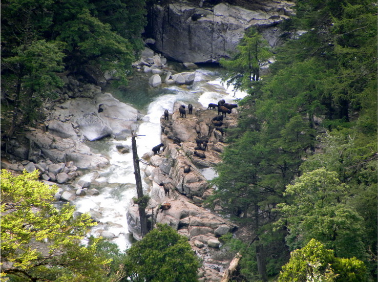
The site is a point where three biogeographic regions meet. They are the world’s major biogeographic zones, and thus the site is a rich biodiversity spot. Two-thirds of the site’s fauna are endemic to the region and the site also acts as a corridor for several species. The fauna includes leopard (Panthera pardus), snow leopard (Uncia uncia), musk deer (Muschus fuscus), takin (Budorcas taxicolor), etc. This scenic site hosts various species of bird and has the highest gathering of birds in all of China. The Tibetan, Bai, Pumi, Yi, Lisu, Miao, Dulong, Naxi and Nu peoples are among the 13 ethnic groups settled within the scenic area. These ethnic groups preserve many ancient traditions and customs. The Naxi people of Jinshajiang Valley are an exceptional instance of a matrilineal society (Nomination file 2003).
The lofty mountains of northwest Yunnan Province form a natural landscape known as the Three Parallel Rivers of Yunnan Province. The site was inscribed as a UNESCO World Heritage Site in 2003. The natural heritage site comprises 15 protected areas clustered in eight geographical regions. The landscape was named Three Parallel Rivers because the three great rivers of East Asia, namely the Jinsha River (the upper reaches of the Yangtze River), the Lancang River (the upper reaches of the Mekong River) and the Nujiang River (the upper reaches of the Salween River) flow in the north–south direction parallel to each other through the Gaoligong Mountains, Yunling Mountains, Dandanlika Mountains, Mount Fury and other mountains (Rong2017).
The Indian summer monsoon brings humid air with 80% or more precipitation; winters are generally dry and cold (Cheng et al 2018). According to Cheng, the vegetation of the Three Parallel Rivers region differs by niche along the altitudinal gradient, and this is a prominent aspect of the vegetation of the site. Cheng also divided the vegetation of the Three Parallel Rivers region into five categories: Savanna (1900-3000m), Coniferous and Broad-Leaved Mixed Forests (3000–3800 m), Abies (3800–4100 m), Alpine Shrubs (4000–4350 m) and Alpine Meadows (4350–4500 m).
The site is a point where three biogeographic regions meet. They are the world’s major biogeographic zones, and thus the site is a rich biodiversity spot. Two-thirds of the site’s fauna are endemic to the region and the site also acts as a corridor for several species. The fauna includes leopard (Panthera pardus), snow leopard (Uncia uncia), musk deer (Muschus fuscus), takin (Budorcas taxicolor), etc. This scenic site hosts various species of bird and has the highest gathering of birds in all of China. The Tibetan, Bai, Pumi, Yi, Lisu, Miao, Dulong, Naxi and Nu peoples are among the 13 ethnic groups settled within the scenic area. These ethnic groups preserve many ancient traditions and customs. The Naxi people of Jinshajiang Valley are an exceptional instance of a matrilineal society (Nomination file 2003).
Criterion (vii)
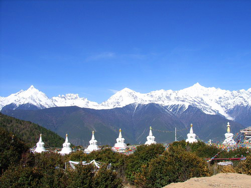
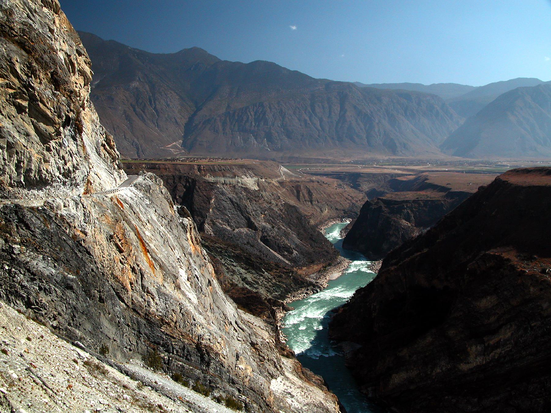 The deep, parallel gorges of the Jinsha, Lancang and Nu Jiang are the outstanding natural feature of the property; while large sections of the three rivers lie just outside the property boundaries, the river gorges are nevertheless the dominant scenic element in the area. High mountains are everywhere, with the glaciated peaks of the Meili, Baima and Haba Snow Mountains providing a spectacular scenic skyline. The Mingyongqia Glacier is a notable natural phenomenon, descending to 2700 m altitude from Mt Kawagebo (6740 m), and is claimed to be the glacier descending to the lowest altitude for such a low latitude (28° N) in the northern hemisphere. Other outstanding scenic landforms are the alpine karst (especially the 'stone moon' in the Moon Mountain Scenic Area above the Nu Jiang Gorge) and the 'tortoise shell' weathering of the alpine Danxia.
Criterion (viii)
The property is of outstanding value for displaying the geological history of the last 50 million years associated with the collision of the Indian Plate with the Eurasian Plate, the closure of the ancient Tethys Sea, and the uplifting of the Himalaya Range and the Tibetan Plateau. These were major geological events in the evolution of the land surface of Asia and they are on-going. The diverse rock types within the property record this history and, in addition, the range of karst, granite monolith, and Danxia sandstone landforms in the alpine zone include some of the best of their type in the mountains of the world.
Criterion (ix)
The dramatic expression of ecological processes in the Three Parallel Rivers property has resulted from a mix of geological, climatic and topographical effects. First, the location of the area within an active orographic belt has resulted in a wide range of rock substrates from igneous (four types) through to various sedimentary types including limestones, sandstones and conglomerates. An exceptional range of topographical features - from gorges to karst to glaciated peaks -- is associated with the property being at a "collision point" of tectonic plates. Add the fact that the area was a Pleistocene refugium and is located at a biogeographical convergence zone (i.e. with temperate and tropical elements) and the physical foundations for evolution of its high biodiversity are all present. Along with the landscape diversity with a steep gradient of almost 6000m vertical, a monsoon climate affects most of the area and provides another favourable ecological stimulus that has allowed the full range of temperate Palearctic biomes to develop.
Criterion (x)
Northwest Yunnan is the area of richest biodiversity in China and may be the most biologically diverse temperate region on earth. The property encompasses most of the natural habitats in the Hengduan Mountains, one of the world's most important remaining areas for the conservation of the earth's biodiversity. The outstanding topographic and climatic diversity of the property, coupled with its location at the juncture of the East Asia, Southeast Asia, and Tibetan Plateau, biogeographical realms and its function as a N-S corridor for the movement of plants and animals (especially during the ice ages), marks it as a truly unique landscape, which still retains a high degree of natural character despite thousands of years of human habitation. As the last remaining stronghold for an extensive suite of rare and endangered plants and animals, the property is of Outstanding Universal Value.
Status
 With its exceptional biodiversity and natural aesthetic value, the Three Parallel Rivers of Yunnan Province is a major scenic site in China. It consists of 15 protected areas—the management of eight clusters with 15 protected areas is a huge task. The site was inscribed as a UNESCO World Heritage Site in 2003, and the general management plan of the site has been reviewed by the World Heritage committee. The committee expressed concern that the State Party’s plan focuses on developing the site through tourism rather than conserving its natural diversity. According to IUCN, the extent and nature of the development might affect the Outstanding Universal Value of the property. State of Conservation Report 2004 states that the committee received reports of a proposal to construct 13 dams on the Nu Jiang River when the site was being reviewed. Reportedly, a number of them are located either within or in close proximity to the heritage site.
The review of SOCs of showed that the State Party had suspended the planning and approval of dam construction within the property and had made efforts to increase the coordination between the eight properties of the World Heritage Site. The committee had asked the State Party to run a Strategic Environmental Assessment (SEA) of the Electricity Transfer Project and its direct and indirect impacts on the Outstanding Universal Value (OUV) of the property. The committee had also offered assistance in the form of the technical expertise of the World Heritage Centre and IUCN for the preparation of such a SEA. The committee also suggested a systematic programme to monitor the current status and trends of wildlife populations. This would facilitate the formulation of a plan for the conservation and management of the wildlife of the property (SOC 2013). In the State of Conservation (SOC) Report 2017, the committee reiterated that the information contained in the EIAs continued to be of limited depth and was not of the required quality with respect to the scale of the planned hydropower plant, particularly about the additional pressure that would result from the water diversion programme. The committee was concerned that the Strategic Environmental Assessment (SEA) was not aligned with IUCN World Heritage Advice Note and asked to further elaborate the SEA. However, the conservation and management plan and the ecological restoration programme (after mining) of the State Party were commended by the committee. The establishment of an overarching management effectiveness assessment (MEA) system was encouraged by the committee, and the State Party was asked to take advantage of the system.
The 2020 IUCN World Heritage Outlook Assessment showed that there are some significant concerns regarding the conservation of the site. Three Parallel Rivers is a large serial property, and there have been consistent reports of poaching, illegal wildlife trade and mass tourism. These pose a significant threat to the OUV of the property. Issues with the management and the local stakeholders and community are the other threats that are worrisome to the State Party. Although the permanent halting of mining projects and cessation of issue of mining licenses within the site and the buffer zones have had some positive effects, the plan of converting the three major rivers into a series of hydropower dams is another concern that the State Party faces.
With its exceptional biodiversity and natural aesthetic value, the Three Parallel Rivers of Yunnan Province is a major scenic site in China. It consists of 15 protected areas—the management of eight clusters with 15 protected areas is a huge task. The site was inscribed as a UNESCO World Heritage Site in 2003, and the general management plan of the site has been reviewed by the World Heritage committee. The committee expressed concern that the State Party’s plan focuses on developing the site through tourism rather than conserving its natural diversity. According to IUCN, the extent and nature of the development might affect the Outstanding Universal Value of the property. State of Conservation Report 2004 states that the committee received reports of a proposal to construct 13 dams on the Nu Jiang River when the site was being reviewed. Reportedly, a number of them are located either within or in close proximity to the heritage site.
The review of SOCs of showed that the State Party had suspended the planning and approval of dam construction within the property and had made efforts to increase the coordination between the eight properties of the World Heritage Site. The committee had asked the State Party to run a Strategic Environmental Assessment (SEA) of the Electricity Transfer Project and its direct and indirect impacts on the Outstanding Universal Value (OUV) of the property. The committee had also offered assistance in the form of the technical expertise of the World Heritage Centre and IUCN for the preparation of such a SEA. The committee also suggested a systematic programme to monitor the current status and trends of wildlife populations. This would facilitate the formulation of a plan for the conservation and management of the wildlife of the property (SOC 2013). In the State of Conservation (SOC) Report 2017, the committee reiterated that the information contained in the EIAs continued to be of limited depth and was not of the required quality with respect to the scale of the planned hydropower plant, particularly about the additional pressure that would result from the water diversion programme. The committee was concerned that the Strategic Environmental Assessment (SEA) was not aligned with IUCN World Heritage Advice Note and asked to further elaborate the SEA. However, the conservation and management plan and the ecological restoration programme (after mining) of the State Party were commended by the committee. The establishment of an overarching management effectiveness assessment (MEA) system was encouraged by the committee, and the State Party was asked to take advantage of the system.
The 2020 IUCN World Heritage Outlook Assessment showed that there are some significant concerns regarding the conservation of the site. Three Parallel Rivers is a large serial property, and there have been consistent reports of poaching, illegal wildlife trade and mass tourism. These pose a significant threat to the OUV of the property. Issues with the management and the local stakeholders and community are the other threats that are worrisome to the State Party. Although the permanent halting of mining projects and cessation of issue of mining licenses within the site and the buffer zones have had some positive effects, the plan of converting the three major rivers into a series of hydropower dams is another concern that the State Party faces.