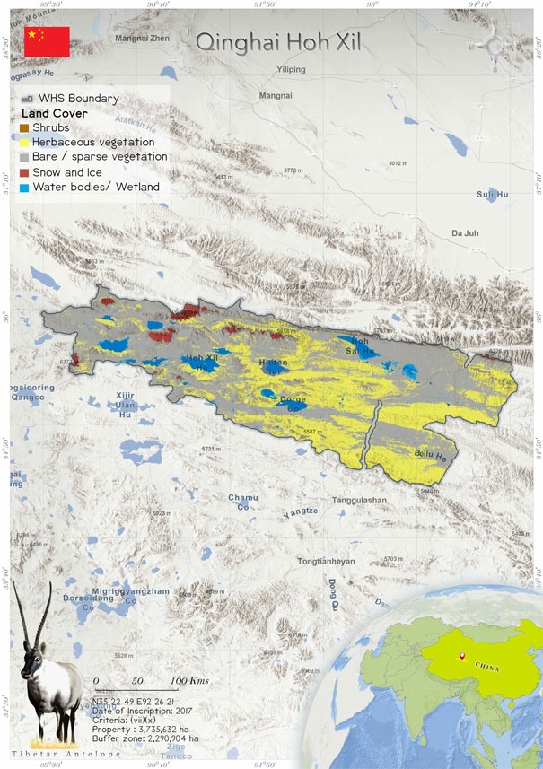
Qinghai Hoh Xil (1540)
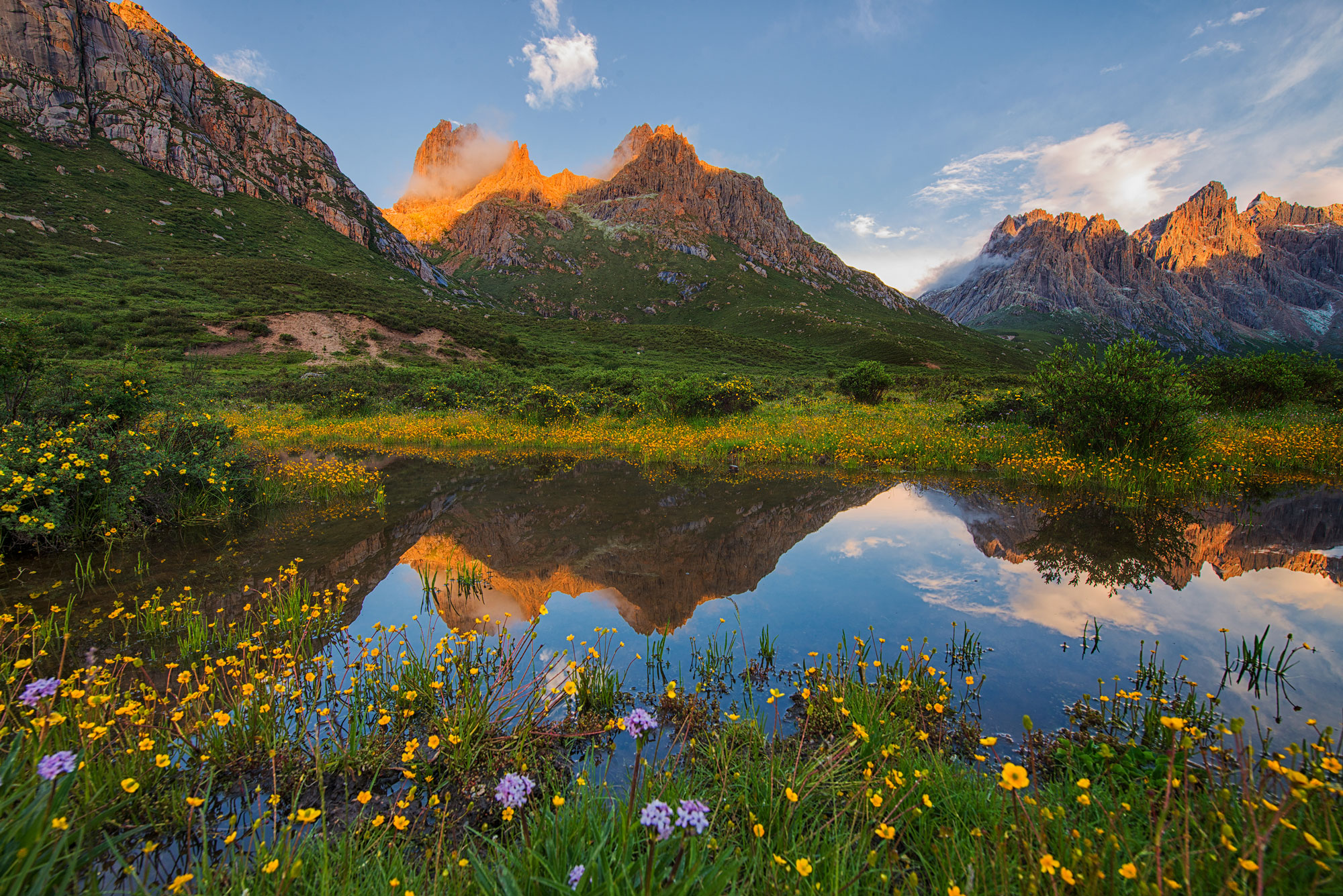
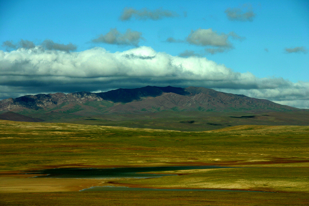
 Qinghai Hoh Xil is situated in the north-eastern side of the Qinghai-Tibetan Plateau. It has an extent of 3,735,632 ha, including a buffer zone of 2,290,904 ha. The site consists of a vast range of alpine mountains and steppe systems at an elevation of 4500 m above sea level. The temperature is around -45°C all year long. The harsh and uninhabited landscape appears as though it is frozen in time. However, there are different geomorphological and ecological systems within the site. Thanks to the unique geography and climate conditions, more than a third of the plant species are endemic to the plateau and herbivorous mammals are highly dependent on them. More than 60% of the mammal species are endemic to the place. The frozen alpine grasslands and meadows covering Hoh Xil’s lake basins are for the population of the Tibetan antelope of the plateau, supporting its migrations. Due to the extreme harsh climatic conditions of the property, there are few human influences, but grazing is a threat to conservation. The engagement between the governments at the central and local levels, communities, NGOs and research institutions is through an effective management system that coordinates human and financial resources. The current threats affecting the property includes railway and highway corridor. Climate change poses a great risk to the landscape and to the survival of the biodiversity. Fencing and agricultural activities such as grazing also affect the aesthetic values of the site. The potential threats include habitat shifting, renewable energy and tourism.
 The site is located in the region identified with the highest concentration of lakes in the plateau region. It showcases an outstanding diversity of lake basins and inland lacustrine landscapes at high altitudes. However, the same area has shifting geomorphological and ecological systems. The unique geography and climate conditions support the biodiversity. The frozen alpine grasslands and meadows of Hoh Xil’s lake basins is important for the Tibetan antelope population of the plateau and its patterns of migration. One migration route, from Sanjiangyuan to Hoh Xil, lies entirely in the property. Even though Qinghai-Tibet Highway and the Qinghai-Tibet Railway cross it, it is prominently the best protected Tibetan antelope route. The property is subject to the harsh reality of climate change, including increasing temperatures and changing precipitation patterns. Though the property is extensive, it could encompass a much larger area. There is no buffer zone in the western and northern sides of the property. The property is adjacent to three well-protected areas in Qinghai Province, the Tibetan Autonomous Region and the Xinjiang Autonomous Region. On the western side of the heritage site is the Hoh Xii National Natural Reserve, which is entirely uninhabited. Similarly, the eastern side of the Soja-Qumar River sub-zone of Sanjiagyuan National Nature Reserve has remained in a pristine condition. The area braces the traditional nomadic lifestyle of Tibetan pastoralists who have co-existed with conservation for a long time. The communities manifest a strong commitment to participatory conservation efforts. The property serves as a site of biological and ecological evolution on the highlands of Pamir-Tian-Shan Highlands stretches across the Eurasian Forest floristic sub-region and Asian desert floristic subregion. There are differences between the floras of the northern and southern slopes. The diverse plants illustrate the ecological and biological evolution of the Pamir-Tian-Shan Highlands. Because of the patterned deserts on one mountain, the deep location in Asia’s hinterland and the arid continental climate, there are unique mountain ecosystems, landforms, ecosystems, habitats and landscapes that have not undergone significant changes since the Pliocene epoch (5 Ma).
Criterion (vii)
Qinghai Hoh Xil is situated on the Qinghai-Tibetan Plateau, the world's largest, highest, and youngest plateau. The property is a place of extraordinary beauty at a scale that dwarfs the human dimension, and which embraces all the senses. The contrast of scale is a recurring theme in Hoh Xil as high plateau systems function unimpeded on a grand scale, wildlife is vividly juxtaposed against vast treeless backdrops and tiny cushion plants contrast against towering snow-covered mountains. In the summer, the tiny cushion plants form a sea of vegetation, which when blooming creates waves of different colours. Around the hot springs at the foot of towering snow-covered mountains, the smells of dust, ash and sulphur combine with the sharp cold wind from the glacier. Glacial melt waters create numerous braided rivers which are woven into huge wetland systems forming tens of thousands of lakes of all colours and shapes. The lake basins comprise flat, open terrain incorporating the best-preserved planation surface on the Qinghai¬Tibet Plateau as well as an unparalleled concentration of lakes. The lakes display a full spectrum of succession stages, forming an important catchment at the source of the Yangtze River and a spectacular landscape. The lake basins also provide the major calving grounds of the Tibetan antelope. In early summer each year, tens of thousands of female Tibetan antelopes migrate for hundreds of kilometres from wintering areas in Changtang in the west, the Altun Mountains in the north and Sanjiangyuan in the east to Hoh Xil’s lake basins to calve. The property secures the complete antelope migratory route between Sanjiangyuan and Hoh Xil, supporting the unimpeded migration of Tibetan antelope, one of the endangered large mammal species endemic to the Plateau.
Criterion (x)
High levels of endemism within the flora of the property are associated with high altitudes and cold climate and contribute to similarly high levels of endemism within the fauna. Alpine grasslands make up 45% of the total vegetation in the property dominated by the grass Stipa purpurea. Other vegetation types include alpine meadows and alpine talus. Over one third of the higher plants found in the property are endemic to the Plateau and all of the herbivorous mammals that feed on these plants are also Plateau endemics. There are 74 species of vertebrates in Hoh Xil, including 19 mammals, 48 birds, six fish, and one reptile (Phrynocephalus vliangalii). The property is home to Tibetan antelope, wild yak, Tibetan wild ass, Tibetan gazelle, wolf and brown bear, all of which are frequently seen. Large numbers of wild ungulates depend on the property including almost 40% of the world's Tibetan antelope and up to 50% of the world's wild yak. Hoh Xil conserves the habitats and natural processes of a complete life cycle of the Tibetan antelope, including the phenomenon of congregating females giving birth after a long migration. The calving grounds in Hoh Xil support up to 30,000 animals each year and include almost 80% of the identified birth congregation areas in the entire antelope range. During the winter, some 40,000 Tibetan antelopes remain in the property, accounting for 20-40% of the global population.
Status
The property is owned and protected by the state at the national level. The engagement the governments at the central and local levels, communities, NGOs and research institutions is through an effective management system through which human and financial resources are coordinated. The concerted work by the stakeholders has ensured the site's survival. The central and local legal protection is maintained efficiently, because of which the natural state of the wilderness is preserved. The Qinghai Hoh Xil Property Management Plan guides the conservation and management efforts that provide a blueprint of the vision and objectives for maintaining and augmenting the Outstanding Universal Values and sequencing management activities directed at improving protection. The plan includes management by local Tibetan herders who reside within the property. There is a buffer zone for conservation, management, research and education. The plan considers monitoring and promotion of sustainable tourism development and long-term management along the transport corridor crossing the property and buffer zone. The threats affecting the property include railway and highway corridors. Climate change poses a serious threat to the landscape and the biodiversity. Fencing and agricultural activities such as grazing also affect the aesthetic values of the site and require management responses. The highway constructed potentially threatens the survival of the Tibetan antelope in the Sanjiangyuan National Nature Reserve. It disturbs the ecological network of the plateau. The management monitors wildlife movements at selected locations of the highway using CCTV. Patrolling by the guards of oh Xil National Nature Reserve, rescuing of antelopes on the highway by the staff of the reserve with the help of suitably located protection stations to allow animals to pass are other measures. As a result of the conservation efforts, the population of the wild animals has been increasing, and there may be conflicts in the future; however, there is no committed plan for conservation (IUCN 2017). Similarly, the railway construction attempted to consider the corridors constructed for antelopes to facilitate optimal migration (Xu et al. 2019). The impact of construction must be included in the monitoring (IUCN 2017), considering the location and structural characteristics for optimal movement (IUCN Consultation 2020). Fencing, mainly in illegal settlements, affects the migration of the Tibetan antelope. Though NGOs and the authorities have made several efforts, many fences are still in place (IUCN 2017). The government offers incentives and compensation to the households to desist from grazing on the land. IUCN notes that the grazing activity has considerably fallen in the recent years. It is important to identify the long-standing traditional grazing intensities supported by the natural ecosystem to develop better conservation practices (IUCN 2017). Invasive species such as Stellera chamaejasme have colonized the areas where the vegetation is degraded and there is overgrazing by livestock (IUCN 2017). Since the property was inscribed only in 2017, it is difficult to assess the effectiveness of the management plan. As noted by IUCN, the plan will undergo regular reviews (IUCN 2020) to improve the management practices. The ongoing protection and monitoring efforts to check the effectiveness need to be strengthened with a systematic feedback loop for the local herding community. It must be strengthened and institutionalized at a higher level (IUCN 2017). On the whole, the protection and management system does not entirely address the risks associated with the site’s values. It is crucial to evaluate and monitor the site’s overall protection and management issues and evolve practical management efforts for the areas around the site.