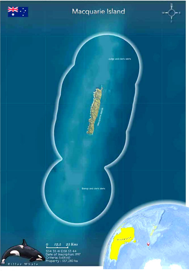
 Macquarie Island lies in the Southern Ocean,
halfway between Australia and Antarctica. The site
includes Macquarie Island, Judge, Clerk and Bishop
islets, rocks, reefs and the surrounding waters to a
distance of 22 km from the shore. The site has an extent
of 540km2
, of which 127 km2
is land. Being inscribed as
a World Heritage Site in 1997, it is the only place on our
planet where rocks from the Earth's mantle are being
actively exposed above sea level.
Macquarie Island lies in the Southern Ocean,
halfway between Australia and Antarctica. The site
includes Macquarie Island, Judge, Clerk and Bishop
islets, rocks, reefs and the surrounding waters to a
distance of 22 km from the shore. The site has an extent
of 540km2
, of which 127 km2
is land. Being inscribed as
a World Heritage Site in 1997, it is the only place on our
planet where rocks from the Earth's mantle are being
actively exposed above sea level.
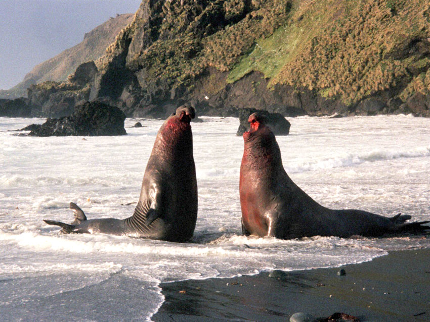
The site provides information about the various geological processes in the region and hence is of great geo-conservation value. It is home to a variety of plants and animals. A large variety of vascular and other plants are found here. The site is devoid of any terrestrial mammals, and only marine mammals, including the southern right whale, killer whale, southern elephant seal and New Zealand fur seal, are present. The Tasmanian Government is responsible for the day-to-day management of the site. The overall management has been effective in dealing with the issues in the region. Climate change is a major threat here. There has been effective management of invasive species. According to the IUCN World Heritage Outlook Report 2020, the site is facing low levels of threats and is of less concern.
 Macquarie Island is an oceanic island that lies in
the Southern Ocean, halfway between Australia and
Antarctica (540 35' 41" S and 1580 53' 44" E latitudes)
and 1500 km southeast of Tasmania. The site includes
Macquarie Island, Judge, Clerk, and Bishop islets, rocks,
reefs and the surrounding waters to a distance of 22 km
from the shore. The island is unique as it is composed
entirely of oceanic crust and rocks from the mantle,
deep below the Earth's surface. Macquarie Island is 34
km long and 5 km wide. The island lies in the latitudes
commonly known as the Furious Fifties because of the
mighty wind and stormy seas (Claudino 2018). It was
inscribed in 1997 when Macquarie Island Marine Park
was created (UNEP/WCMC 2013). The islands of the site
were never inhabited and are owned by the state of
Tasmania. The site has an Outstanding Universal Value for two
reasons. First, for providing information on the various
geological processes in the region. It is the only place
on Earth where rocks from the mantle are actively
exposed.
Macquarie Island is an oceanic island that lies in
the Southern Ocean, halfway between Australia and
Antarctica (540 35' 41" S and 1580 53' 44" E latitudes)
and 1500 km southeast of Tasmania. The site includes
Macquarie Island, Judge, Clerk, and Bishop islets, rocks,
reefs and the surrounding waters to a distance of 22 km
from the shore. The island is unique as it is composed
entirely of oceanic crust and rocks from the mantle,
deep below the Earth's surface. Macquarie Island is 34
km long and 5 km wide. The island lies in the latitudes
commonly known as the Furious Fifties because of the
mighty wind and stormy seas (Claudino 2018). It was
inscribed in 1997 when Macquarie Island Marine Park
was created (UNEP/WCMC 2013). The islands of the site
were never inhabited and are owned by the state of
Tasmania. The site has an Outstanding Universal Value for two
reasons. First, for providing information on the various
geological processes in the region. It is the only place
on Earth where rocks from the mantle are actively
exposed.
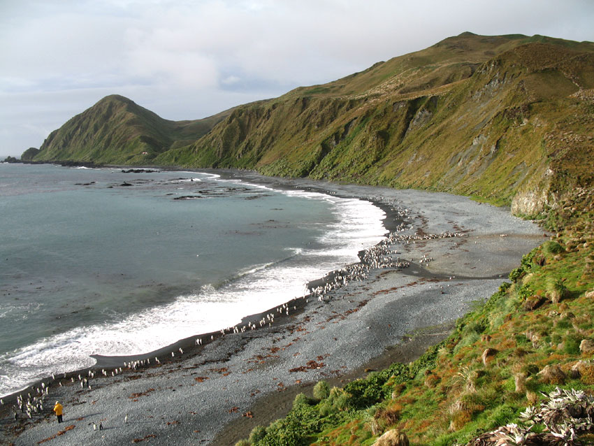
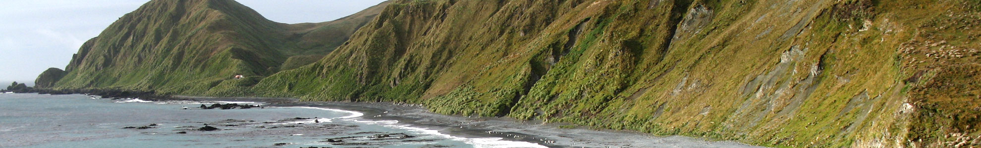
 Second, its remote and windswept landscape
of steep escarpments, lakes and vegetation provides
an example of outstanding natural beauty and is of
great geo-conservation significance. A coastal terrace
is formed near the shoreline from a wave-cut platform
that rises above sea level. The coastal platforms have
vast waterlogged areas that are heavily vegetated and
are locally known as "featherbeds". Steep escarpments
rising more than 200 m to undulating plateaus are
present behind the coastal terrace. These have three
peaks over 400 m, the highest being Mount Hamilton,
433 m (Australian government 2021).
Second, its remote and windswept landscape
of steep escarpments, lakes and vegetation provides
an example of outstanding natural beauty and is of
great geo-conservation significance. A coastal terrace
is formed near the shoreline from a wave-cut platform
that rises above sea level. The coastal platforms have
vast waterlogged areas that are heavily vegetated and
are locally known as "featherbeds". Steep escarpments
rising more than 200 m to undulating plateaus are
present behind the coastal terrace. These have three
peaks over 400 m, the highest being Mount Hamilton,
433 m (Australian government 2021).
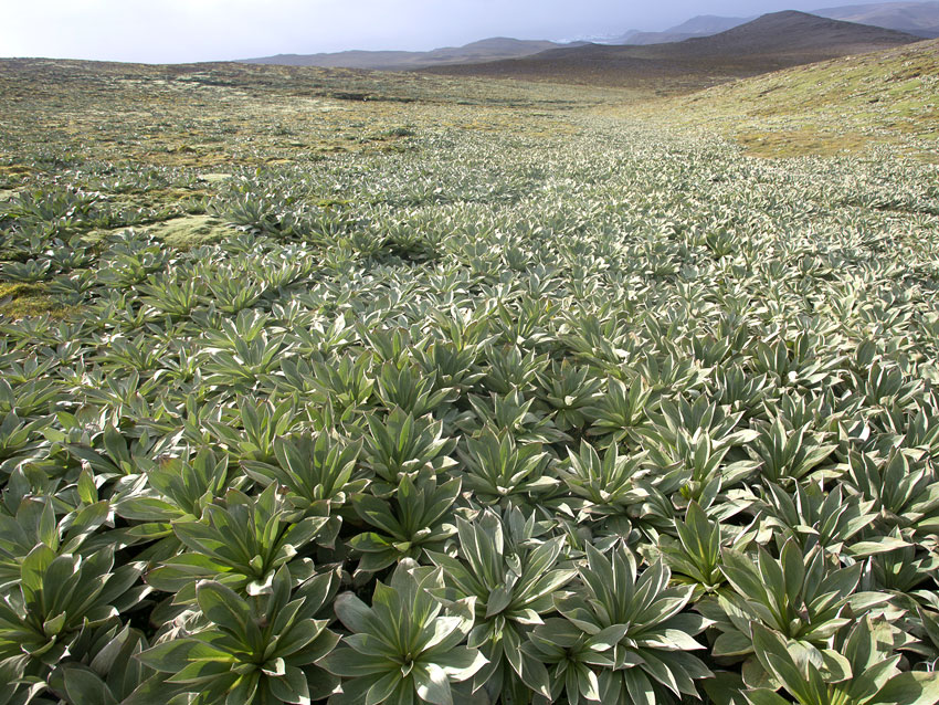
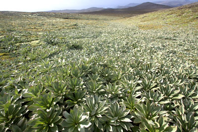
There are five main vegetation formations: tall tussock grassland, short tussock grassland (herb field), fen, bog and Feldmark (Selkirk et al. 1990). Dramatic changes in the vegetation occur with topography changes, varying from lush grassland to sparse. There are 47 native species of vascular plant, of which four are endemic and three are listed as threatened. There are also more than 80 species of moss, 50 liverworts and some 141 species of lichen. Twenty species of freshwater alga, 90 diatoms and 110 species of marine and littoral alga are found here (Ricker 1981).
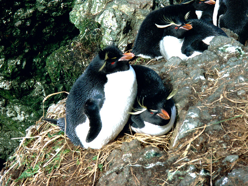
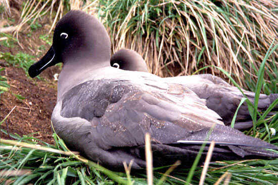
 Four species of albatross, four petrels and the brown
skua (Stercorarius skua) species breed on the island
(Andersson 1999). The Macquarie islands have no native
terrestrial mammals, and the indigenous mammals are
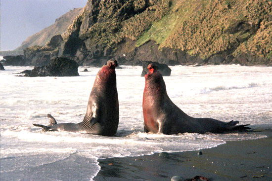
all marine. They include the southern right whale, killer
whale, southern elephant seal, New Zealand fur seal,
subantarctic fur seal and Antarctic fur seal. There are
no native passerine species in the region. An endemic
subspecies of the imperial shag (Leucocarbo albiventer
purpurascens) breeds on Macquarie Island and the nearby Bishop and Clerk islets (IUCN World Heritage
Outlook 2020).
Four species of albatross, four petrels and the brown
skua (Stercorarius skua) species breed on the island
(Andersson 1999). The Macquarie islands have no native
terrestrial mammals, and the indigenous mammals are
all marine. They include the southern right whale, killer
whale, southern elephant seal, New Zealand fur seal,
subantarctic fur seal and Antarctic fur seal. There are
no native passerine species in the region. An endemic
subspecies of the imperial shag (Leucocarbo albiventer
purpurascens) breeds on Macquarie Island and the nearby Bishop and Clerk islets (IUCN World Heritage
Outlook 2020).
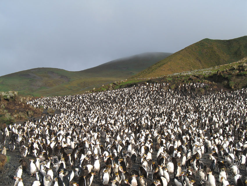
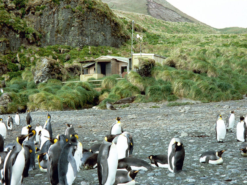
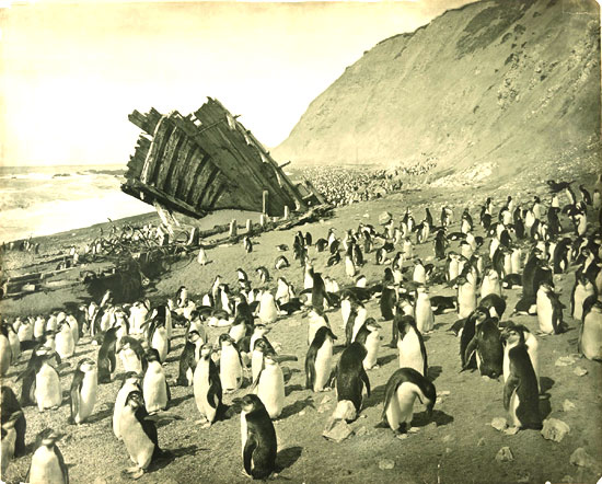
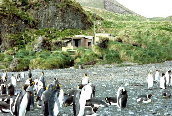
The site is home to many seals and birds that spend most of the time in the sea but come ashore during the breeding season. At that time, there is a huge congregation of penguins and seals. King and gentoo Penguins remain year-round at the site (UNESCO 2012; State Party of Australia 1996). The breeding population of royal penguins (Eudyptes schlegeli), occurs on Macquarie Island and Bishop and Clerk islets. There are approximately 750,000 royal penguin pairs, making up one of the most significant congregations of sea birds globally (Salton et al. 2019). At the peak, there were estimated to be around 150,000-170,000 breeding pairs of the king penguin (Aptenodytes patagonicus) in 2000 (UNESCO whc.unesco.org).
 Macquarie Island provides an outstanding
spectacle of wild, natural beauty with huge congregations
of penguins and seals populating what has been described
as a small speck thrust up into the vast Southern Ocean.
The island lies in latitudes known as the 'Furious Fifties'
because of the frequency of very strong winds and
stormy seas, which have sculpted the island. A coastal
terrace supports vast waterlogged and heavily vegetated
areas, forming a mire based on deep peat beds known
as 'featherbed'. This is framed by steep escarpments
which rise spectacularly to a plateau surface dotted
with innumerable lakes, tarns and pools. The continual
westerly winds, which increase in force as they rise over
the barrier of the island, and changes in topography result
in dramatic changes in the vegetation cover which can
vary from lush grassland to sparse feldmark within the
space of a few meters.
Macquarie Island provides an outstanding
spectacle of wild, natural beauty with huge congregations
of penguins and seals populating what has been described
as a small speck thrust up into the vast Southern Ocean.
The island lies in latitudes known as the 'Furious Fifties'
because of the frequency of very strong winds and
stormy seas, which have sculpted the island. A coastal
terrace supports vast waterlogged and heavily vegetated
areas, forming a mire based on deep peat beds known
as 'featherbed'. This is framed by steep escarpments
which rise spectacularly to a plateau surface dotted
with innumerable lakes, tarns and pools. The continual
westerly winds, which increase in force as they rise over
the barrier of the island, and changes in topography result
in dramatic changes in the vegetation cover which can
vary from lush grassland to sparse feldmark within the
space of a few meters.
Among the most aesthetically appealing features of the island are the vast congregations of wildlife, particularly penguins, during the breeding season. The breeding population of Royal Penguins (Eudyptesschlegeli), a species endemic to Macquarie Island and nearby Bishop and Clerk Islets, is estimated at over 850,000 pairs, one of the greatest congregations of seabirds in the world.
The breeding population of King Penguins (Aptenodytes patagonicus), estimated at around 150,000-170,000 breeding pairs in 2000, is still expanding. As the King Penguin chicks do not leave the vicinity of the nest for a year, they survive the rigours of winter by huddling together on the windy and snow-swept beaches. Four species of albatross nest on steep and rugged cliffs and are easily viewed when nesting. Elephant Seals (Mirounga leonina) also form impressive colonies during the breeding season.
 Macquarie Island and its outlying islets are
geologically unique in being the only place on earth where
rocks from the earth's mantle are being actively exposed
above sea level. The island is the exposed crest of the
undersea Macquarie Ridge, raised to its present position
where the Indo-Australian tectonic plate meets the Pacific
plate. These unique exposures provide an exceptionally
complete section of the structure and composition of
both the oceanic crust and the upper mantle, and provide
evidence of 'sea-floor spreading' and tectonic processes
that have operated for hundreds of millions of years.
The geological evolution of Macquarie Island began 10
million years ago and continues today with the island
experiencing earthquakes and a rapid rate of uplift, all of
which are related to active geological processes along the
boundary between the two plates.
Macquarie Island and its outlying islets are
geologically unique in being the only place on earth where
rocks from the earth's mantle are being actively exposed
above sea level. The island is the exposed crest of the
undersea Macquarie Ridge, raised to its present position
where the Indo-Australian tectonic plate meets the Pacific
plate. These unique exposures provide an exceptionally
complete section of the structure and composition of
both the oceanic crust and the upper mantle, and provide
evidence of 'sea-floor spreading' and tectonic processes
that have operated for hundreds of millions of years.
The geological evolution of Macquarie Island began 10
million years ago and continues today with the island
experiencing earthquakes and a rapid rate of uplift, all of
which are related to active geological processes along the
boundary between the two plates.
Sequences from all crustal levels, down to 6 kilometers below the ocean floor, are exposed as a result of tilting and differential uplift on Macquarie Island. This provides rare evidence for sequences that are common from the bottom of the oceans to the upper mantle, but not seen elsewhere in surface outcrops. The lack of deformation of this exposed crust is highly significant as it exhibits key interrelated and interdependent oceanic crustal elements in their natural relationship.
Macquarie Island is the only ophiolite (a well-developed and studied geological complex) recognized to have been formed within a major ocean basin. The geology of the island is therefore considered to be the connecting link between the ophiolites of continental environments and those located within the oceanic crust.
 The management of thr park is under
Tasmania Parks and Wildlife Service. The islands are
not inhabited and hence are not affected by human
interventions. Longline fishing is a significant threat
to the marine organisms in the region. However, with
the effectiveness of the management, it has been
eradicated. In recent years, eight invasive alien plant
species have been recorded in the region (Visoiu 2019).
The management of thr park is under
Tasmania Parks and Wildlife Service. The islands are
not inhabited and hence are not affected by human
interventions. Longline fishing is a significant threat
to the marine organisms in the region. However, with
the effectiveness of the management, it has been
eradicated. In recent years, eight invasive alien plant
species have been recorded in the region (Visoiu 2019).
Climate change is primarily responsible for an increase in temperature and altered precipitation patterns and hence impacts the endemic vegetation of the region (Scott & Kirkpatrick 2013). It has also led to an increase in the extent of invasive plant species in the island (Bergstrom et al. 2015). Die back of Azorella macquariensis is one notable threat in the region. Plastic pollution is also a major threat. In a study conducted by Eriksson and Burton (2003), plastic pellets were obtained from the scats of fur seals.
The island visit management protocols are highly effective, and all the official visits to Macquarie Island are well regulated. The investment in the new research station on the island provides assurance of the long-term commitment of the Australian Government Department of the Environment and Energy's Australian Antarctic Division, along with the Tasmanian Government (through the Department of Primary Industries, Parks, Water, and Environment) to conserve the Outstanding Universal Value of Macquarie Island.