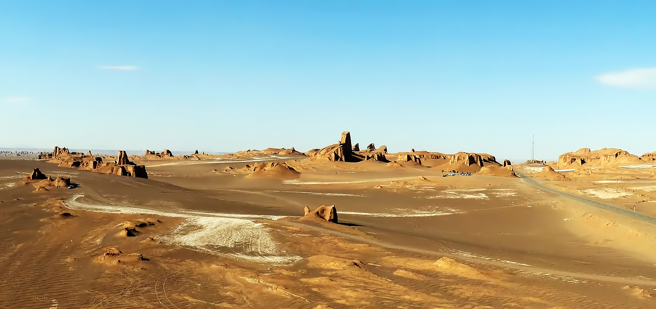
Lut Desert (1505)
 The Lut Desert, of Iran, has drawn considerable attention from researchers, geologists and tourists for its unique geomorphological structures, which have been created by environmental and climatic conditions. The sandhills, kaluts, nebkhas and yardangs, and many other features, have made the place a World Heritage Site. The Lut Desert is known as the hottest and driest bioclimatic zone in the world as the temperature can hit 80°C at the maximum. The people living around the desert are well-adapted to the climate and rely on the minimal vegetation that grows around the nebkhas and on small freshwater basins formed by precipitation seasonally. They are supported financially by the tourism activities within the buffer zone of the property. However, as the site attracts tourists for several activities, there has been erosion of the landform structures as well as desertification. This heritage site, with geological structures shaped over years, is a nation’s pride and needs to be preserved.
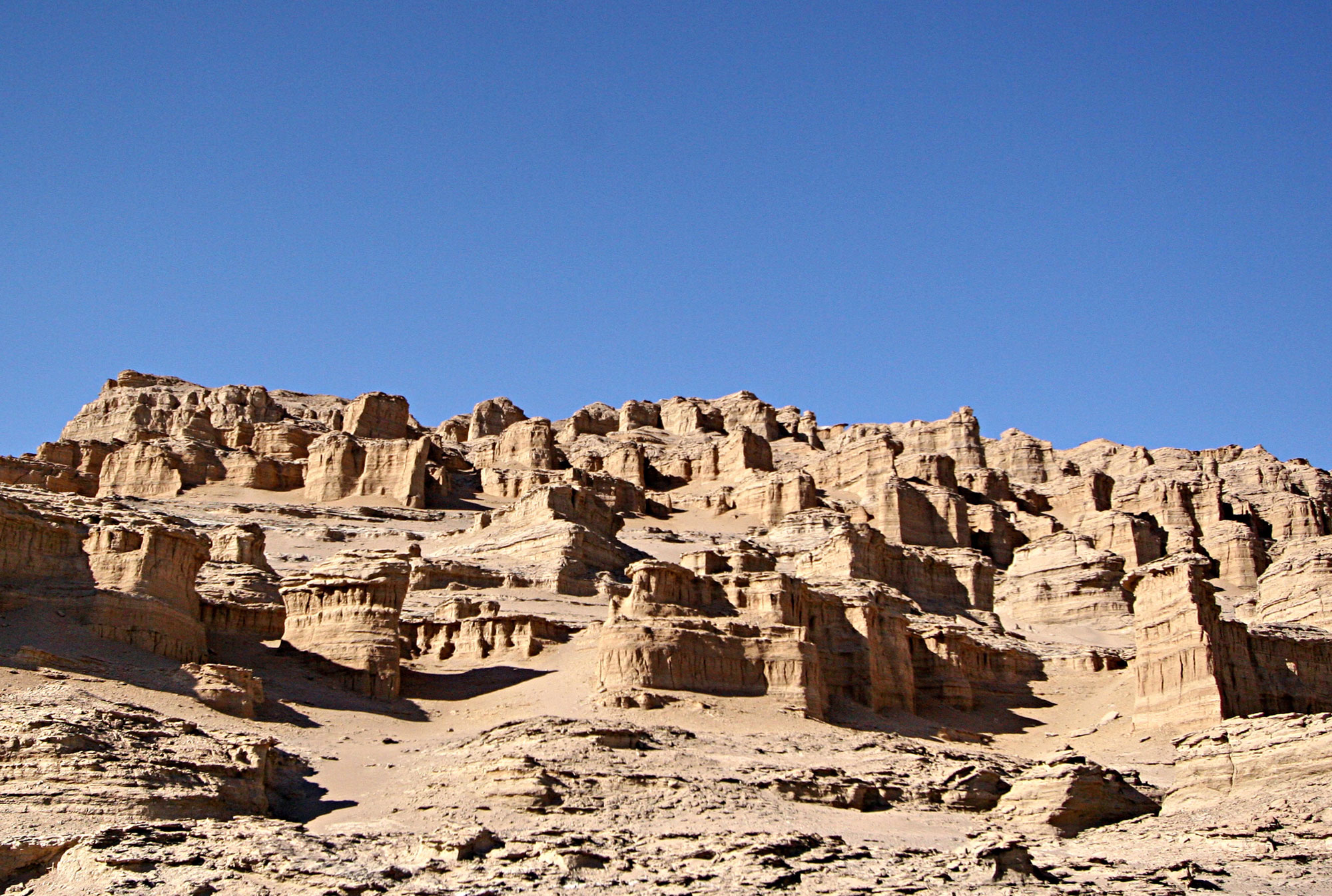
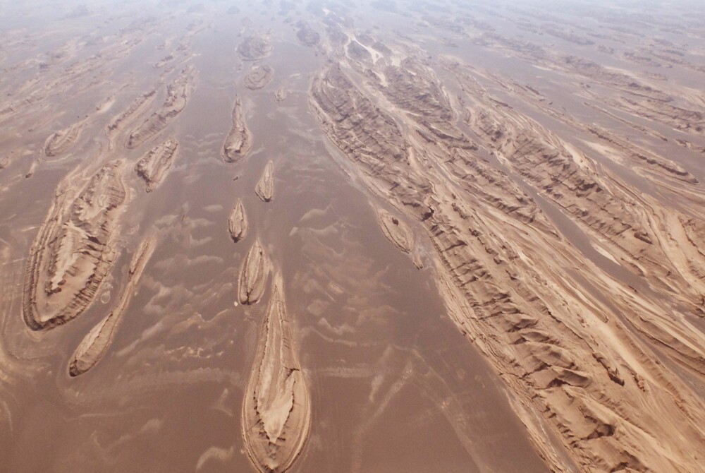
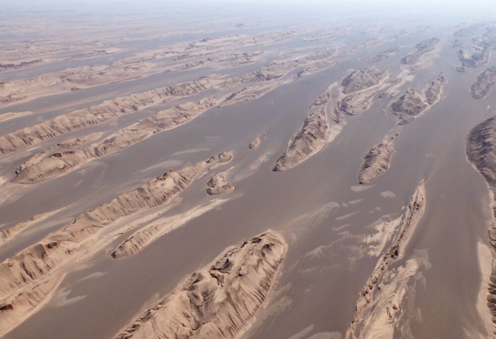
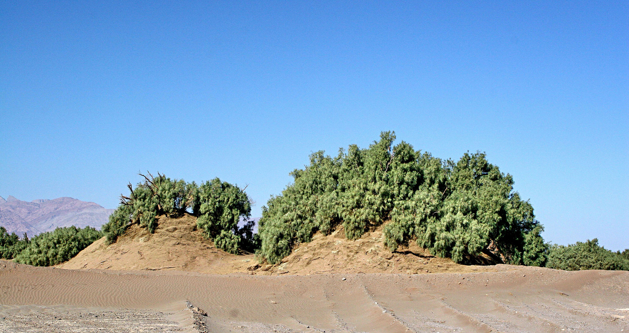
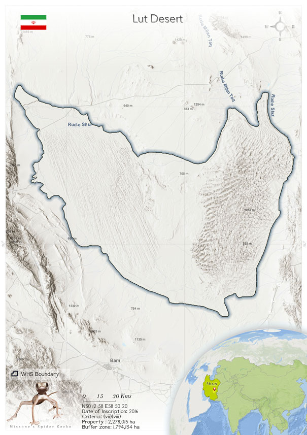
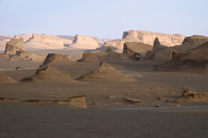
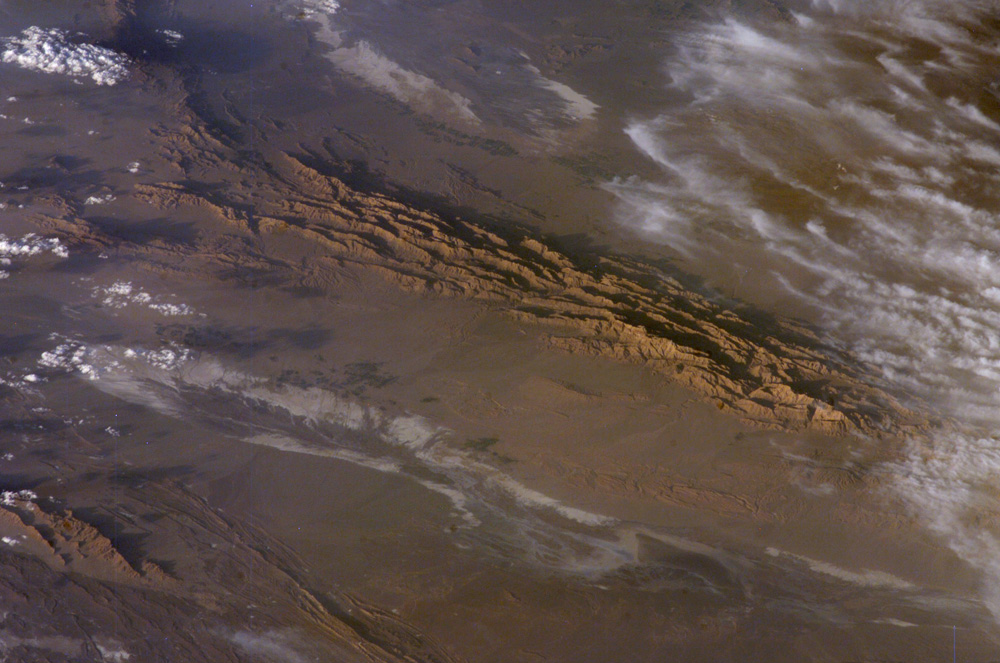 The Lut Desert, also known as Dasht-e-Lut, located in the south-eastern part of Iran, is the hottest desert on this planet. According to a satellite survey carried out in 2006, the surface temperature of the desert was measured to be 70.7°C, and Lut Desert was designated the "Thermal Pole of Earth" (Mildrexler et al. 2006). In 2017, another satellite surface temperature survey indicated that the temperature range rose to 78.2–80.8°C (Azarderakhsh et al. 2020), with the mean temperature ranging between -2.6°C, in winter, and 50.4°C, in summer (Lyons et al. 2020). Because Lut Desert is a hyper-arid zone, the annual precipitation is less than 30 mm; according to Global Bioclimate, it is the hottest and driest bioclimatic region in the world (Djamali et al. 2011). Lut Desert has a vast extent of 2,278,015 ha, which falls in several provinces of Iran, such as Kerman, Sistan-Baluchistan and southern Khorasan (Selivanon 1982). The desert experiences strong winds from spring to summer due to the north–south pressure gradient (World heritage datasheet 2016). This has led to various prominent landforms such as mega-aeolin yardangs (kaluts), nebkhas, sandhills, desert pavements, and large flat areas of saline soils (Alavipanah et al. 2007; Ehsani 2011). Yardangs are small sandhills with long furrows, whereas nebkhas are areas with wind-drifted sediments of sand, silt, clay and gravel formed in tamarisk trees on flat ground with a high groundwater level (Abdollah et al. 2014). Kaluts, on the other hand, are mega-yardangs that are much larger in size, with elongated ridges and downwind tapered ends. These are created by gushes of wind and rain, resulting in thick deposits of salty clay on the flanks. Kaluts are also gullied so that there is a shallow groundwater system on some of the ridges (Kerber &Radebaugh 2017). Another landform is the Yallan Sand Sea, also known as Rig-e Yallan, which extends over a rectangular area with an extent of more than 10,000 km2 with north–south alignment in the eastern part of the Lut Desert (Taleghani 2009). It extends over a distance of 150 km from north to south and 70 km from east to west. The Hamada plain or desert pavement is found in the central part of the Lut. It appears to have a reverse triangular shape. Its head is in the south, towards the Shurgaz Hamun playas (Taleghani 2009).
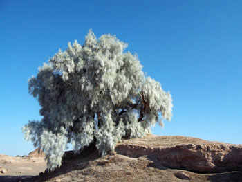
The biodiversity of Lut Desert is negligible due to the high temperatures and low rainfall, as a result of which most of the area is harsh and arid and devoid of any plant and animal life. Whatever water is received is supplied by the Rud-e-shur River, which originates from the north-west mountains in Birjand. The salinity of this water is about the 134.3 g L-2. It flows into a large central saline basin from the north-western edges of the desert (Shirsalimian et al. 2017). However, studies have confirmed that a few species of Arachnida (spider fauna) can survive in this intense environment. The number of spider species had increased significantly from 141 in 2014 to almost 700 in 2018 (Zamani et al. 2018). In the Lut Desert, over 15 species belonging to 12 families were discovered, including Benoitia lepida, Devade tenella, Stegodyphus lineatus, Gnaphosa ukrainica, Haplodrassus caspius, Aelurillus unitibialis and Megalepthyphantes camelus (Zamani &Marusik 2018). In 2017, individuals of Phallocryptus were discovered and identified in a seasonal freshwater lake of comparatively lower salinity compared with the rest of the desert (Shirsalimian et al. 2017). In 2020, another species, Phallocryptus fahimii sp. n. was identified in the southern part of the Lut Desert (Schwentnera et al. 2020) These are crustacean taxa that inhabit areas with hypo- to meso-saline water bodies in arid or semi-arid regions.
The Lut Desert, also known as Dasht-e-Lut, located in the south-eastern part of Iran, is the hottest desert on this planet. According to a satellite survey carried out in 2006, the surface temperature of the desert was measured to be 70.7°C, and Lut Desert was designated the "Thermal Pole of Earth" (Mildrexler et al. 2006). In 2017, another satellite surface temperature survey indicated that the temperature range rose to 78.2–80.8°C (Azarderakhsh et al. 2020), with the mean temperature ranging between -2.6°C, in winter, and 50.4°C, in summer (Lyons et al. 2020). Because Lut Desert is a hyper-arid zone, the annual precipitation is less than 30 mm; according to Global Bioclimate, it is the hottest and driest bioclimatic region in the world (Djamali et al. 2011). Lut Desert has a vast extent of 2,278,015 ha, which falls in several provinces of Iran, such as Kerman, Sistan-Baluchistan and southern Khorasan (Selivanon 1982). The desert experiences strong winds from spring to summer due to the north–south pressure gradient (World heritage datasheet 2016). This has led to various prominent landforms such as mega-aeolin yardangs (kaluts), nebkhas, sandhills, desert pavements, and large flat areas of saline soils (Alavipanah et al. 2007; Ehsani 2011). Yardangs are small sandhills with long furrows, whereas nebkhas are areas with wind-drifted sediments of sand, silt, clay and gravel formed in tamarisk trees on flat ground with a high groundwater level (Abdollah et al. 2014). Kaluts, on the other hand, are mega-yardangs that are much larger in size, with elongated ridges and downwind tapered ends. These are created by gushes of wind and rain, resulting in thick deposits of salty clay on the flanks. Kaluts are also gullied so that there is a shallow groundwater system on some of the ridges (Kerber &Radebaugh 2017). Another landform is the Yallan Sand Sea, also known as Rig-e Yallan, which extends over a rectangular area with an extent of more than 10,000 km2 with north–south alignment in the eastern part of the Lut Desert (Taleghani 2009). It extends over a distance of 150 km from north to south and 70 km from east to west. The Hamada plain or desert pavement is found in the central part of the Lut. It appears to have a reverse triangular shape. Its head is in the south, towards the Shurgaz Hamun playas (Taleghani 2009).
The biodiversity of Lut Desert is negligible due to the high temperatures and low rainfall, as a result of which most of the area is harsh and arid and devoid of any plant and animal life. Whatever water is received is supplied by the Rud-e-shur River, which originates from the north-west mountains in Birjand. The salinity of this water is about the 134.3 g L-2. It flows into a large central saline basin from the north-western edges of the desert (Shirsalimian et al. 2017). However, studies have confirmed that a few species of Arachnida (spider fauna) can survive in this intense environment. The number of spider species had increased significantly from 141 in 2014 to almost 700 in 2018 (Zamani et al. 2018). In the Lut Desert, over 15 species belonging to 12 families were discovered, including Benoitia lepida, Devade tenella, Stegodyphus lineatus, Gnaphosa ukrainica, Haplodrassus caspius, Aelurillus unitibialis and Megalepthyphantes camelus (Zamani &Marusik 2018). In 2017, individuals of Phallocryptus were discovered and identified in a seasonal freshwater lake of comparatively lower salinity compared with the rest of the desert (Shirsalimian et al. 2017). In 2020, another species, Phallocryptus fahimii sp. n. was identified in the southern part of the Lut Desert (Schwentnera et al. 2020) These are crustacean taxa that inhabit areas with hypo- to meso-saline water bodies in arid or semi-arid regions.
Criterion (vii)
 The Lut Desert protects a globally-recognized iconic hot desert landscape, one of the hottest places on earth. It is renowned for its spectacular series of landforms, namely the yardangs (massive corrugated ridges) in the west of the property and the sand-sea in the east. The yardangs are so large and impressive that they can be seen easily from space. Lut is particularly significant for the great variety of desert landform types found in a relatively small area. Key attributes of the aesthetic values of the unspoilt property relate to the diversity and sheer scale of its landforms; a visually stunning mosaic of desert colours; and uninterrupted vistas across huge and varied dune systems that transition into large flat desert pavement areas.
Criterion (viii)
 The property represents an exceptional example of ongoing geological processes related to erosional and depositional features in a hot desert. The yardang/kalut landforms are widely considered the best-expressed in the world in terms of extent, unbroken continuity and height. The Lut sand-seas are amongst the best developed active dune fields in the world, displaying a wide variety of dune types (crescentic ridges, star dunes, complex linear dunes, funnel-shaped dunes) with dunes amongst the highest observed anywhere on our planet. Nebkha dune fields (dunes formed around plants) are widespread with those at Lut as high as any measured elsewhere. Evaporite (salt) landforms are displayed in wide variety, including white salt-crusted crystalline riverbeds, salt pans (playa) with polygonally fractured crusts, pressure-induced tepee-fractured salt crusts, gypsum domes, small salt pingos (or blisters), and salt karren. Other dry-land landforms include extensive hamada (stony desert pavements or reg) usually located on pediment surfaces with wind faceted stones (ventifacts), gullied badlands and alluvial fans (bajada).
Status
 The Lut Desert is a site of extreme climatic and topographical conditions. UNESCO designated it a World Heritage Site for its magnificent sand structures and landforms created by rain, winds and earthquakes, in other terms, geological processes. The Lut Desert was recognized as a hotspot for attracting tourists and for conducting research studies. The presence of nique geo-sites allowed geo-tourism to expand in the area. Geo-tourism was considered an effective way of conserving national heritage and promoting regional development (Rodrigues et al. 2011).
However, according to a report submitted by IUCN in 2017, the Lut Desert faced several threats that would potentially affect the geomorphology of the area. For instance, several villages were established on the western edge of the desert over the years that brought along with them livelihood activities such as logging, wood collection, cattle grazing and construction of roads. Many informal road networks through the heritage site that disturbed its topography, especially in the Shur Valley. Further, the nebkhas and the Rud-e-shur River area are more fertile and support more vegetation compared with the rest of the area. As a result, people began encroaching on them for cattle grazing and harvesting fodder stock. Soon, that led to desertification and destruction of the soil composition.
Tourism is also a threat in terms of infrastructure construction. With a growing influx of tourists, there comes the incentive to build up accommodation centres and tracks for vehicles within the property’s buffer zone. Therefore, the national and state governments prepared specific management policies to manage and take care of the national heritage property. For example, provisions were made to facilitate tourist access by land or air and accommodation at the site by making corridors that avoided the main fragile areas of the desert. Areas with kaluts, yardangs and nebkhas were handled with extra security by licensed operators to prevent noticeable impacts on the structures. The local and indigenous people around the desert were included in the management committee. They were aware of the geographical and climatic conditions and conserved the property that provided employment opportunities. Education and awareness schemes were also provided to those who stood in conserving a World Heritage Property. The Lut Desert is state-owned, and the state-level authorities work with three agencies that share conservation and management responsibilities for the heritage site. These are Forests, Range and Watershed Management Organization; Iranian Department of Environment; and the Iran Cultural Heritage, Handicrafts and Tourism Organization (IUCN 2016).
Since, the Lut Desert has been newly (in 2016) designated a World Heritage Site by UNESCO, the management committee has not been able to lay down stringent policies for its conservation and management as yet. As a result, both national and regional government members have decided to cooperate and contribute to the establishment of the World Heritage Property. It is considered reasonable to emphasize integrating the property into regional and national planning systems and work together to result in an effective outcome. Recently, several unique “Bases” were set up as a measure to improve management. There is one Base at the national level in Tehran for integrated management, three Bases at provincial centres involved in Lut Desert management and eight local field Bases in towns and villages around the Lut Desert heritage site (IUCN Consultation 2020).
The Lut Desert is a site of extreme climatic and topographical conditions. UNESCO designated it a World Heritage Site for its magnificent sand structures and landforms created by rain, winds and earthquakes, in other terms, geological processes. The Lut Desert was recognized as a hotspot for attracting tourists and for conducting research studies. The presence of nique geo-sites allowed geo-tourism to expand in the area. Geo-tourism was considered an effective way of conserving national heritage and promoting regional development (Rodrigues et al. 2011).
However, according to a report submitted by IUCN in 2017, the Lut Desert faced several threats that would potentially affect the geomorphology of the area. For instance, several villages were established on the western edge of the desert over the years that brought along with them livelihood activities such as logging, wood collection, cattle grazing and construction of roads. Many informal road networks through the heritage site that disturbed its topography, especially in the Shur Valley. Further, the nebkhas and the Rud-e-shur River area are more fertile and support more vegetation compared with the rest of the area. As a result, people began encroaching on them for cattle grazing and harvesting fodder stock. Soon, that led to desertification and destruction of the soil composition.
Tourism is also a threat in terms of infrastructure construction. With a growing influx of tourists, there comes the incentive to build up accommodation centres and tracks for vehicles within the property’s buffer zone. Therefore, the national and state governments prepared specific management policies to manage and take care of the national heritage property. For example, provisions were made to facilitate tourist access by land or air and accommodation at the site by making corridors that avoided the main fragile areas of the desert. Areas with kaluts, yardangs and nebkhas were handled with extra security by licensed operators to prevent noticeable impacts on the structures. The local and indigenous people around the desert were included in the management committee. They were aware of the geographical and climatic conditions and conserved the property that provided employment opportunities. Education and awareness schemes were also provided to those who stood in conserving a World Heritage Property. The Lut Desert is state-owned, and the state-level authorities work with three agencies that share conservation and management responsibilities for the heritage site. These are Forests, Range and Watershed Management Organization; Iranian Department of Environment; and the Iran Cultural Heritage, Handicrafts and Tourism Organization (IUCN 2016).
Since, the Lut Desert has been newly (in 2016) designated a World Heritage Site by UNESCO, the management committee has not been able to lay down stringent policies for its conservation and management as yet. As a result, both national and regional government members have decided to cooperate and contribute to the establishment of the World Heritage Property. It is considered reasonable to emphasize integrating the property into regional and national planning systems and work together to result in an effective outcome. Recently, several unique “Bases” were set up as a measure to improve management. There is one Base at the national level in Tehran for integrated management, three Bases at provincial centres involved in Lut Desert management and eight local field Bases in towns and villages around the Lut Desert heritage site (IUCN Consultation 2020).